Subject: Bristol Channel
Period: 1589 (circa)
Publication: Spieghel der Zeevaerdt
Color: Hand Color
Size:
20.3 x 13.6 inches
51.6 x 34.5 cm
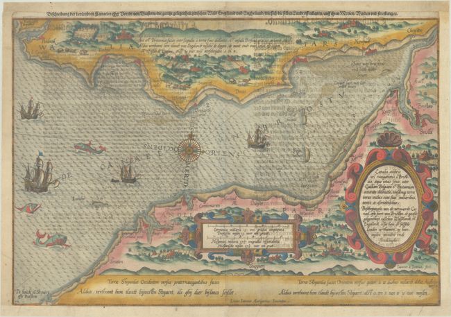
This superb sea chart depicts Bristol Channel, showing the southern coastline from Padstow to Bristol, and the Welsh coastline from Pembroke to Chepstow. The surrounding countryside is depicted in graphic detail, with farmhouses, tiny towns, rolling hills, and livestock. The map is further embellished with two strapwork cartouches, a compass rose, galleons, and sea monsters. This is the second state, with plate number "XIX" engraved at lower left.
The map is from a German text edition of the Spieghel der Zeevaerdt, the first detailed atlas of charts covering the coastlines of Europe, originally published in Dutch in 1584-85. In addition to the Dutch and Latin titles on the map itself, an alternate German title appears along the upper neatline: Beschreibung der Beruemhten Canaelen oder Voerdt von Bristow. Waghenaer's charts are renowned for their fine engraving by the best craftsmen of the period, including Theodore de Bry and the Doetecum brothers. This map was engraved by Joannes Doetecum. German text on verso.
References: Koeman, Wag 6 #XIX.
Condition: B+
A dark impression on a bright sheet with show-through of text on verso. The map has been trimmed to the neatline on three sides and professionally remargined with period-correct paper.