Subject: Southern Mexico & Guatemala
Period: 1794 (dated)
Publication:
Color: Black & White
Size:
24.8 x 18.5 inches
63 x 47 cm
Thomas Jefferys was one of the most important English map publishers of the 18th century. His work included prints and maps of locations around the world, but his most notable maps are of North America and the West Indies. He began his career in the map trade in the early 1730s, working as an engraver for a variety of London publishers, and eventually setting up his own shop. In 1746, he was appointed Geographer to the Prince of Wales, and in 1760 he became Geographer to the King. These titles granted access to manuscripts and cartographic information held by the government. In the early 1760s he embarked on an ambitious project to produce a series of English county maps based on new surveys, but ran out of money and filed for bankruptcy in 1766. He then partnered with London publisher Robert Sayer, who reissued many of Jefferys plates and continued to issue new editions after Jefferys' death in 1771. Jefferys' American Atlas and the accompanying West-India Atlas, published post posthumously, are considered his most important cartographic works.
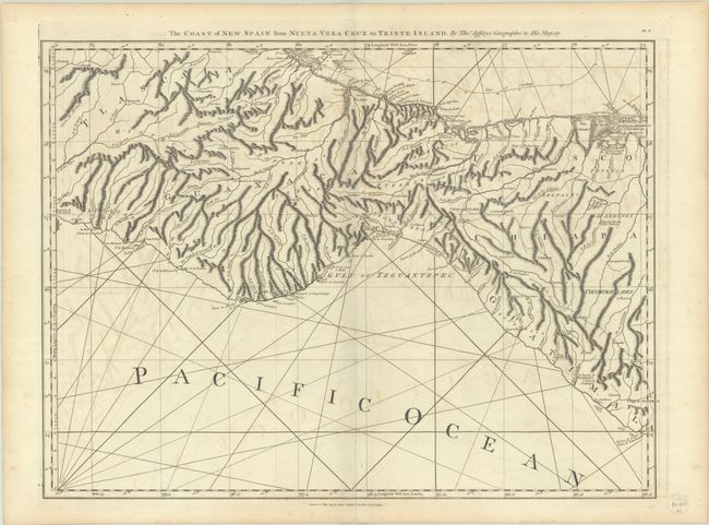
This excellent view of the Isthmus of Tehuantepec shows cities, villages, missions, volcanoes, roads, and finely rendered topography. The map extends to show part of Guatemala. This edition has been updated to show several new towns and an extensive road system. One sheet of the 16-sheet map of the West Indies that formed the heart of the important Revolutionary-period atlas. Sheet number BE.9 printed at upper right. First issued by Jefferys in 1775, this is the Laurie & Whittle edition.
References: cf. Shirley (BL Atlases) M.JEF-4a #15.
Condition: B+
A dark impression on paper with the coat of arms watermark of Lubbert van Gerrevink. There is light offsetting and a bit of toning along the edges of the sheet.