Subject: Southwestern United States & Mexico
Period: 1825 (circa)
Publication:
Color: Hand Color
Size:
12.7 x 18.1 inches
32.3 x 46 cm
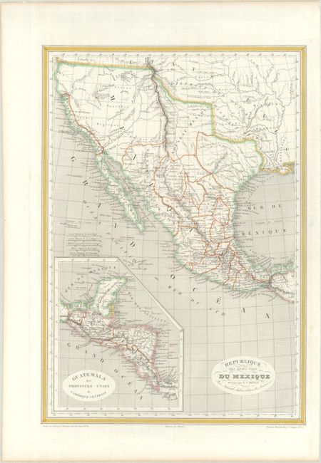
This scarce map depicts Mexico extending north to the 42nd parallel and east to the Sabine River, as established by the Adams-Onis Treaty of 1819. On this earlier edition of the map, Texas is outlined but not named, with San Antonio, San Felipe, Goliad, and Nagodoches among the few cities identified. Nouveau Mexique is located south of the Arkansas River, with Santa Fe, Albuquerque, and Taos named. The provinces of Mexico are delineated. Arkansas, Missouri, Louisiana and Mississippi are noted but their borders are not laid out on the map. The Osage and Ozarks districts are prominently shown along with other tribal lands. The western topography is represented in hachure and is based on the expeditions of Lewis and Clark, Pike, and Long. The Great Salt Lake appears in the Great Basin with an incomplete western shore, and a speculative wetland in the region is linked to the Pacific via a conjectural east-west R. Sacramento. Includes an inset of Central America at bottom left. Engraved on steel by Grenier, with lettering by Benard. Printed by Mangeon.
References:
Condition: A
A crisp impression on a sturdy sheet that has been professionally backed with archival tissue.