Subject: United States, Mexico & Central America
Period: 1860 (dated)
Publication:
Color: Black & White
Size:
19.5 x 16.4 inches
49.5 x 41.7 cm
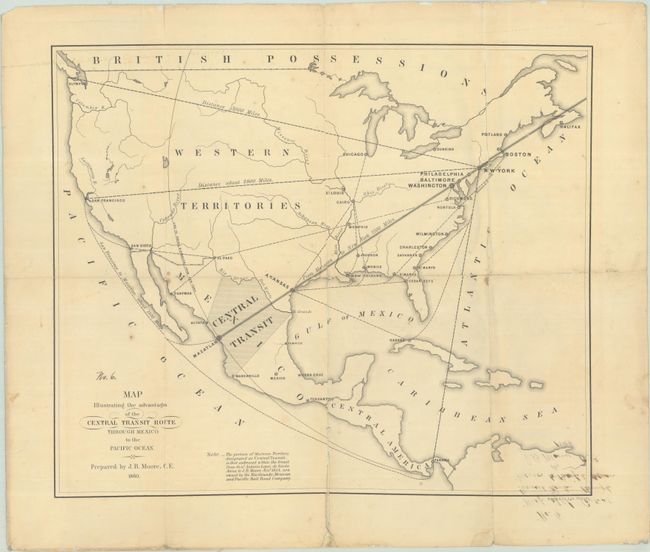
This map promotes the idea of constructing a railroad from New York to Mazatlan, Mexico that provided a shorter route (2,100 miles) to the Pacific Ocean over possible railroads to San Francisco (2,900 miles) and Seattle (3,000 miles). This route illustrates a huge "Central Transit" grant (taking up a third of Mexico!) "from General Antonio Lopez de Santa Anna to J.B. Moore November 1854, now owned by the Rio Grande, Mexican and Pacific Railroad Company" which gave government permission to construct the line in Mexico. Unfortunately for the company, Congress passed the Pacific Railroad Bill in 1862, designating the 32nd parallel as the first transcontinental route. This map (and others) likely accompanied a company report and includes the manuscript addition "No. 6" above the title. Lithographed by Bowen & Company in Philadelphia. We found only one past sales record in 1971 and no institutional examples on OCLC.
References: Phillips (Maps) p. 217.
Condition: B
Issued folding and now flattened and backed with linen to repair several small fold separations. There is a bit of foxing and staining and show-through in the bottom right corner from an ink notation on verso. Manuscript addition "No. 6" is above the title.