Subject: World
Period: 1876 (dated)
Publication: Le Monde Illustre
Color: Hand Color
Size:
38.9 x 28.2 inches
98.8 x 71.6 cm
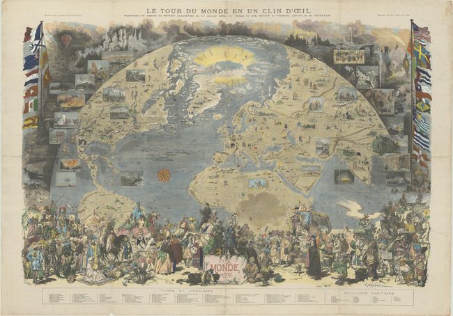
This remarkable, large-format map was drawn by H. Scott and Daniel Vierge, and finely engraved by Fortune Meaulle. It was published as a supplement to the January 1, 1876 issue of Le Monde Illustre, and shows much of the northern hemisphere as if viewed from space. Geographically, the map covers the area from the Equator to the North Pole, and from the western coast of North America to India and Bangladesh. The North Pole is shown as an open ocean and labeled Mer Libre? with explorer names surrounding it - a clear reference to the quest for the Northwest Passage. The continents show inhabitants in their local dress, and native plants and animals are also depicted. Flanking the map are a number of vignettes including gold mining, oil wells, bison, Niagara Falls, Chicago, a Hindu cremation, and more. Beneath the map are an incredible 79 costumed figures numbered to a key. Completing the composition are the flags of 22 nations at left and right.
References: Rumsey #8030.
Condition: B
Issued folding, now flat and professionally backed with archival tissue to reinforce and repair numerous fold separations with some minor losses mostly at the fold junctions along with several repaired tears in the left image ranging in size from 2" to 6". There is minor soiling in the margins.