Subject: Mount Rainier, Washington
Period: 1933 (dated)
Publication:
Color: Printed Color
Size:
18.4 x 18.1 inches
46.7 x 46 cm
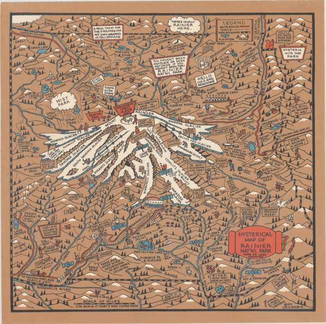
This is a rare early work of Jolly Lindgren, offering an irreverent view of Mount Rainier National Park. It centers roughly on the mountain, depicted in striking snowy white, with several of its glaciers identified. Fans of Lingren's "hysterical" maps will recognize the cartoon wildlife, frolicking figures, and goofy visual puns. Mount Ararat is captioned "What No Ark"; a bird peers down from Columbia Crest thinking, "Darn high down"; a squirrel promises, "You'll go nuts over the scenery." Flames and a pitchfork emerge from Devil's Hole; Ghost and Bench lakes take the shape of their namesakes; a raincloud puns, "There's usually Rainier here." Auto roads are in red, elevations are in blue. The map is copyrighted by Lee R. Double, a Seattle-based advertising agent who issued four of the early Lindgren maps in 1933 and 1934. "Words & Music" are credited to "Jolly" Lindgrin [sic]. The Lindgren brothers took another crack at a Mount Rainier map in 1940, in their typical blue-and-yellow color scheme. This is the only example of this map we have seen on the market.
The Lindgren brothers of Spokane, Washington, specialized in humorous maps of state parks. The brothers founded their business in 1928 with Hjalmer (Jolly) serving as the artist and Oscar (O.S.) overseeing administration and production. They produced their first map in 1932 - Hysterical Map of the Spokane Country Slightly Cockeyed - which was designed to be "hysterical" rather than "historical." Their comical map was successful, and in 1933 others followed, including Puget Sound, Rainier National Park, and Yellowstone National Park. Despite the Great Depression, tourism in national parks increased significantly in the 1930s, and visitors were eager for souvenirs of their trips. The Lindgren brothers capitalized on this trend, producing numerous National Park maps. Beginning with the Yellowstone map, Jolly developed a standardized format with a bold blue border incorporating the title, yellow denoting land (because of Yellowstone), red for roadways, black for text, and accents of green and blue. This style and color scheme became Jolly's signature style and was continued on all of his hysterical maps of national parks. The Lindgren brothers had hired Ted Turner as director of sales in 1930, and his role in the business gradually evolved until he became an official partner in 1949, and the business was renamed Lindgren-Turner. After World War II, the map business declined, so the Lindgrens and Turner innovated to create souvenir decals, which became hugely popular. After Jolly Lindgren's death in 1952, Oscar Lindgren and Ted Turner further extended the product line to include postcards (called "King Size Mapcard").
References:
Condition: A
A crisp example printed on brown paper with a couple short edge tears in the blank margins.