Subject: Everett, Washington
Period: 1898 (circa)
Publication:
Color: Black & White
Size:
18.7 x 17.7 inches
47.5 x 45 cm
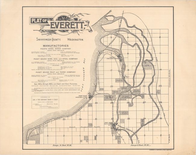
This rare plat map of Everett, Washington was published by the Land and River Improvement Company of Everett. Everett was conceived in 1890 as the "Pittsburgh of the West" by lumberman Henry Hewett, Jr. and railroad executive Charles L. Colby, who saw an opportunity to build an industrial center at the end of the Great Northern Railroad. The plan was published in the first decade of the city's existence and shows the development thus far. Prominently shown are the Pacific Steel Barge Company, Puget Sound Wire, Nail and Steel Company, and Puget Sound Pulp and Paper Company, each of which is listed with stock information, address, and more under the map title. Hewett, Jr. is listed as vice president of the steel company and president of the paper company, with Gardner Colby, probably a relation to the city's co-founder Charles, as treasurer. The Great Northern Railroad snakes along the Puget Sound, with the Snohomish, Skykomish, and Spokane Railroad line connecting to it from the south. An electric line cuts through the center of development. Part of Mukilteo is shown at bottom left. Lithographed in Seattle by Lowman & Hanford. This is the only example of this map we have been able to locate.
References:
Condition: B+
Issued folding on a sheet with a "Scotch Linen Ledger" watermark. There are small light stains in the map image at bottom right, minor extraneous creasing, and marginal edge tears.