Subject: World
Period: 1862 (dated)
Publication:
Color: Hand Color
Size:
43.8 x 29.8 inches
111.3 x 75.7 cm
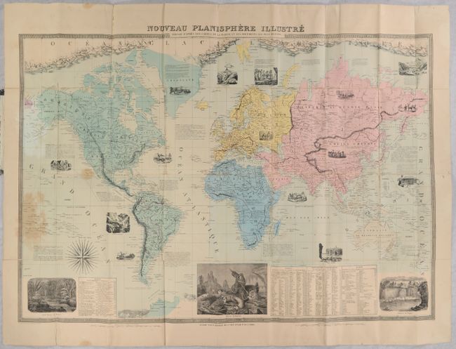
A very large map of the world on Mercator's Projection that was "drawn up according to naval charts and the most recent documents." While countries, rivers and mountains are delineated throughout, emphasis is on the continents which are hand colored including Europe (yellow), Asia (pink), Africa (blue), Australia (gray) and the Americas (green). Notations about the continents and other large geographical areas fill the oceans and are accompanied by attractive illustrations including the Great Wall of China, Port Jackson, Mount Hecla, and panning for gold. In its description of North America, the author notes that the United States has a "rapidly growing population of 25 million inhabitants. It is crisscrossed by railways, possesses a considerable navy, and carries on an immense trade." Larger illustrations along the bottom border feature a virgin forest in Brazil, a dramatic polar bear attack in the Polar Sea, and Niagara Falls. Accompanying tables at bottom include principal geographic discoveries, distance of various capitals to Paris, lengths of river, and heights of mountains. The map is further decorated by a 32-point wind rose and decorative border. Engraved by Delamare and published by B. Renault. Folds into stiff paper boards with paper title label on the front cover (5.8 x 8.9").
References:
Condition: B
Issued folding with some light staining primarily at lower left and numerous fold separations closed on verso with paper tape. Covers are moderately worn.