Subject: Southern Montana & Northern Wyoming
Period: 1938 (dated)
Publication:
Color: Printed Color
Size:
23.6 x 17.6 inches
59.9 x 44.7 cm
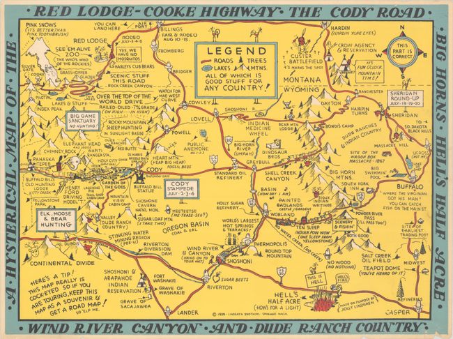
This rare pictorial map by the Lindgren brothers covers the region just west of Yellowstone National Park. It extends from Billings, Montana south to Hell's Half Acre, Wyoming, the latter depicted as a rift in the earth with hellfire blazing out. Among the sites to be seen are Pink Snows north of Silver Gate, the "See 'Em Alive Zoo (The Who's Who of the Rockies)," Red Lodge, Custer Battlefield, "Over the Top of the World Drive" ("Watch for Mae West Curve"), the Buffalo Bill statue outside Cody, the "Garden of the Gods" in Holy City, Wind River and Canyon ("Hang on to Your Hat"), and the Shoshoni and Arapahoe Indian Reservation, with the graves of Sacajawea and Washakie. The map pops with the Lindgren brother's signature jokes and charming illustrations. We have only located one previous example of this map on the market and one institutional copy, held in the David Rumsey Collection.
The Lindgren brothers of Spokane, Washington, specialized in humorous maps of state parks. The brothers founded their business in 1928 with Hjalmer (Jolly) serving as the artist and Oscar (O.S.) overseeing administration and production. They produced their first map in 1932 - Hysterical Map of the Spokane Country Slightly Cockeyed - which was designed to be "hysterical" rather than "historical." Their comical map was successful, and in 1933 others followed, including Puget Sound, Rainier National Park, and Yellowstone National Park. Despite the Great Depression, tourism in national parks increased significantly in the 1930s, and visitors were eager for souvenirs of their trips. The Lindgren brothers capitalized on this trend, producing numerous National Park maps. Beginning with the Yellowstone map, Jolly developed a standardized format with a bold blue border incorporating the title, yellow denoting land (because of Yellowstone), red for roadways, black for text, and accents of green and blue. This style and color scheme became Jolly's signature style and was continued on all of his hysterical maps of national parks. The Lindgren brothers had hired Ted Turner as director of sales in 1930, and his role in the business gradually evolved until he became an official partner in 1949, and the business was renamed Lindgren-Turner. After World War II, the map business declined, so the Lindgrens and Turner innovated to create souvenir decals, which became hugely popular. After Jolly Lindgren's death in 1952, Oscar Lindgren and Ted Turner further extended the product line to include postcards (called "King Size Mapcard").
References: Rumsey #13335.
Condition: B+
There are short edge tears in the margins, a few of which enter into the map border at top and bottom. There is minor extraneous creasing in the bottom right corners, a hint of printer's ink residue at right, and remnants of glue on verso.