Subject: Northern Italy
Period: 1730 (circa)
Publication:
Color: Hand Color
Size:
40.4 x 24.1 inches
102.6 x 61.2 cm
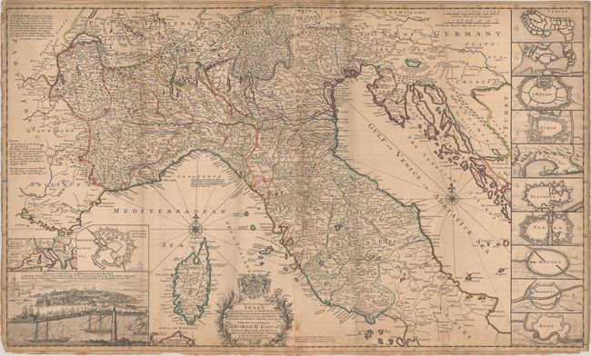
This handsome large map on two joined sheets depicts the northern two-thirds of Italy and the adjacent coasts of France and the northern Balkans. It includes good detail of roads, towns and cities, rivers and lakes, mountains and political boundaries. The map is flanked by 10 insets of fortified cities including Venice, Milan, Florence and Rome along with a miniature Italy with the Adjacent Dominions about It &c. at lower left. A lovely bird's-eye view of Livorno fills the bottom left corner. The imprints of Thomas Bowles and John Bowles appear at bottom.
Herman Moll was one of Britain's most prominent cartographers of the first half of the 18th century. He emigrated from Germany and went to work as an engraver for Moses Pitt in 1678. Soon he joined one of London's most interesting social circles, which gathered at Jonathan's Coffee House, and included stock speculators, scientists, archaeologists, authors, pirates, and sea-captains. From these friends, Moll gained a great deal of privileged information that he compiled into his cartographic works. Moll's success and prosperity was due in part to his social connections and political astuteness, and to his distinctive style and quality workmanship. He produced a great number of often-innovative maps, charts, globes, atlases and geographies. His best known works are the large two-sheet maps produced for his World Described, which were also published separately.
References: Shirley (BL Atlases) T.MOLL-4d #27.
Condition: B
Contemporary outline color on a lightly toned sheet that has been backed with old linen. There is some soiling, a couple small stains, and chipping along the lower border. The linen is partially detached at lower left. Trimmed to the border at left.