Subject: West Virginia & Ohio
Period: 1865 (dated)
Publication:
Color: Hand Color
Size:
37.6 x 30.4 inches
95.5 x 77.2 cm
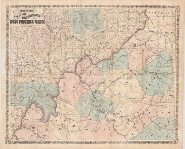
This important map focuses on the oil, natural gas, and coal mining in northwestern West Virginia and southeastern Ohio. The Ohio River extends diagonally across the map, and the locations of oil lands, gas springs and coal banks are noted primarily along the Little Kanawha and Hughes Rivers in West Virginia. The map extends west to McConnelsville and Athens in Ohio and east to West Union and Glenville in West Virginia, and also identifies counties, towns, roads, turnpikes, and railroads. This map was first published in 1865 at the beginning of the region's oil boom; this example is the second edition, and was published the same year with numerous updates and improvements. In addition to extending the scope of the map approximately 18 miles to the east and 4 miles to the north, extensive additional information has been added to Wood, Ritchie, Wirt and Calhoun counties in West Virginia. The route of the South Fork of the Hughes River has also been corrected from the first edition, properly locating the natural resources to be found along the river. The map is surrounded by a decorative floral border, which was added for the second edition. The map was originally folded into boards, however the boards are not included with this example.
References: Philips (Maps) p. 1067; Rumsey #186.002; Streeter #3924.
Condition: B+
Full contemporary color, issued folding and now flattened with light toning along several folds, a few small spots, and archival repairs to separations and small holes along the folds with minute loss of image. There is a small glue stain in the border at left where the map was originally glued onto the boards.