Catalog Archive
Auction 203, Lot 286

One of Only a Few Texas Maps to Depict Wegefarth County

"County Map of Texas, and Indian Territory", Williams, J. David

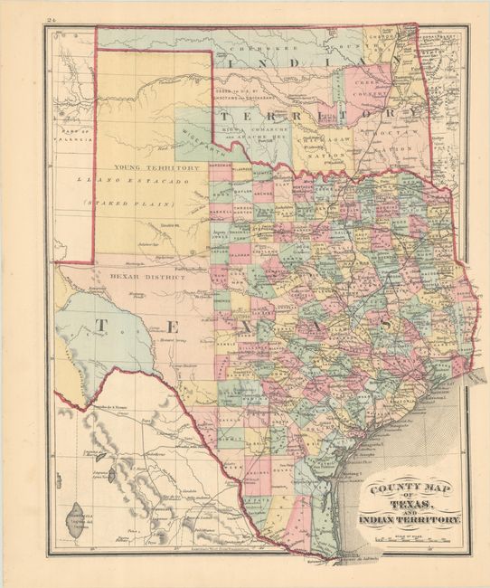
Subject: Texas & Oklahoma

Period: 1875 (circa)

Publication: Illustrated Historical Atlas of Delaware County, Ohio

Color: Hand Color

Size:
12.5 x 15.3 inches
31.8 x 38.9 cm
Download High Resolution Image
(or just click on image to launch the Zoom viewer)

This is only the fourth time in the last 30 years that we have encountered a map that depcits the proposed Wigefarth County in the lower Panhandle along the border of Indian Territory. The county line is only partially engraved with the northern border defined in color alone. Wigefarth here should have been spelled Wegefarth. It was named after Conrad Wegefarth, a German-American and President of the Texas Immigrant Aid and Supply Company. The county was created in 1873 but was quickly abolished in 1876 when the entire panhandle was divided into counties. The map presents the network of roads, trails and railways and includes several proposed railways that were not actually completed. Indian Territory is divided among twelve Native nations along with unassigned lands in the panhandle (click here to learn more about the naming and cartographic evolution of this region). On verso is a County Map of Alabama, Mississippi, Arkansas, and Louisiana.

References:

Condition: A

Contemporary color on a clean sheet.

Estimate: $200 - $230

Sold for: $250

Closed on 4/23/2025

Archived