Subject: Hancock, Maine
Period: 1888 (dated)
Publication:
Color: Printed Color
Size:
27.5 x 18.2 inches
69.9 x 46.2 cm
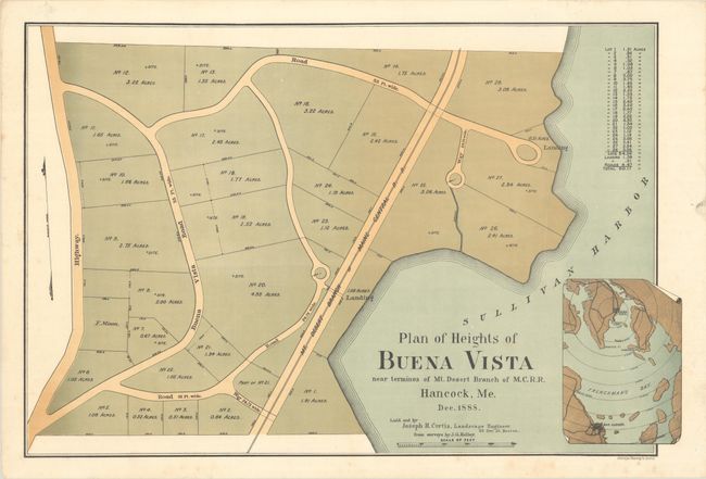
This fascinating and rare map documents a failed 60-acre real estate development called Buena Vista in Hancock Point, Maine. The map was published four-and-a-half years after the completion of the Maine Central Railroad, a line running from Penobscot to the Mount Desert Ferry. With the completion of the railroad, the resort town of Bar Harbor on Mount Desert Island exploded as a popular destination for the Gilded Age elites. Buena Vista, located at the end of the Maine Central line, just mere miles away from the Mount Desert Ferry, would have capitalized on this travel boom. The map delineates 28 lots, ranging from a half acre to 5 acres, with Buena Vista Road and the Mount Desert branch of the Maine Central Railroad passing through. At bottom right is an inset map that highlights the development's proximity to Bar Harbor. "Laid out by Joseph H. Curtis, Landscape Engineer," based on surveys by J.G. Kelley. Printed in Boston by Heliotype Printing Co.
References:
Condition: A
There is a bit of foxing that is mostly confined to the blank margins. There are remnants of hinge tape on verso.