Subject: Northwestern United States
Period: 1847 (dated)
Publication:
Color: Hand Color
Size:
17.3 x 10.8 inches
43.9 x 27.4 cm
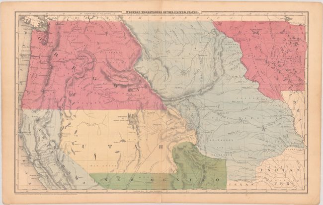
This is a great map showing the transitional boundaries of the American West. Oregon Territory is massive, stretching all the way from the Pacific to the Rocky Mountains at the Continental Divide. The wide Utah Territory reaches across to a huge Nebraska Territory, which extends from Canada's border down to Texas and Indian Territory. A Mormon settlement and the recently established Salt Lake City are noted on the Great Salt Lake; Joseph Smith and his followers settled in this region in 1847. The Gold Region is identified in California. Minnesota also appears as a large territory, which includes a vague Dacotahs region that extends to the Missouri River. Drawn and engraved by Sherman & Smith. This is the second of the three states we can identify (all dated 1847), after the Compromise of 1850 eliminated Texas's extended stovepipe configuration, but before the formation of Kansas Territory in 1854.
References:
Condition: B+
Full contemporary color on a faintly toned sheet with an archivally repaired centerfold separation that enters 1" into map image at bottom. There is light toning around the separation and an ink spot in Utah Territory.