Subject: Croatia
Period: 1593 (published)
Publication: Speculum Orbis Terrae
Color: Black & White
Size:
15.6 x 12.9 inches
39.6 x 32.8 cm
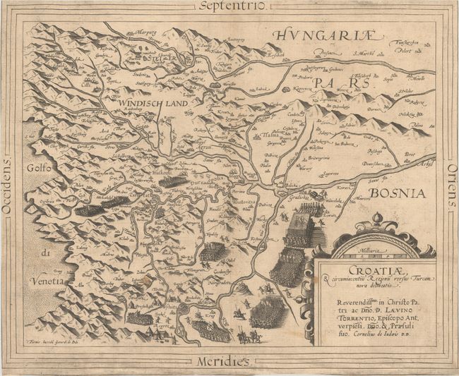
This rare map is one of the earliest maps to focus on Croatia, and was issued during the Long Turkish War (1591-1606), which was fought between the Habsburg Monarchy and the Ottoman Empire. The region is bounded by the cities of Cilli (Celje, Slovenia) in the northwest, Wyhitz (Bihać, Bosnia and Herzegovina) in the south, and Brot (Slavonski Brod, Coatia) in the east. The map shows Ottoman troops marching south from Gradiska to Wyhitz (Bihać), waving their flags emblazoned with a crescent. Towns that were already under Turkish control include a crescent above the miniature city icon, inlcuding Bihać, which had been captured by the Ottomans in June 1592. Other Ottoman troops converge upon Carlstat (Karlovac, Croatia). The cities of Agram (Zagreb) and Sisegg (Sisak) remain under Habsburg rule. The map is dedicated to Laevinus Torrentius, Bishop of Antwerp. Blank verso.
Cornelis de Jode (1568-1600) was the son of the mapmaker and publisher Gerard de Jode. The elder published several important maps, including Ortelius' famous 8-sheet map of the world in 1564. His major atlas, Speculum Orbis Terrarum was a commercial failure because his rival, Abraham Ortelius, was able to obtain a monopoly for eight years at the same time De Jode was preparing the publication. After Gerard's death, his widow and son enlarged the atlas and re-issued it in 1593. On the death of Cornelis, the copper plates were sold to J. B. Vrients, who acquired them merely to stop their re-issue, as he had also acquired the Ortelius plates. De Jode maps are rarely offered on the market. While the atlas did not have much commercial success, de Jode's maps are often regarded as superior in both design and cartographic detail to his more successful competitor, Abraham Ortelius.
References: Shirley (BL Atlases) T.JODE-1c; Van der Krogt (Vol. III) #2740:32B.
Condition: B
A nice impression on a sheet with a small coat of arms watermark. There is light soiling and the sheet has been trimmed on all sides, with partial loss of the border on three sides. The bottom corners of the sheet have been archivally reinforced with old paper on verso.