Subject: Southern United States & Mexico
Period: 1825 (published)
Publication: Atlas Geographique, Statistique, Historique ... des Deux Ameriques
Color: Hand Color
Size:
15.4 x 12.4 inches
39.1 x 31.5 cm
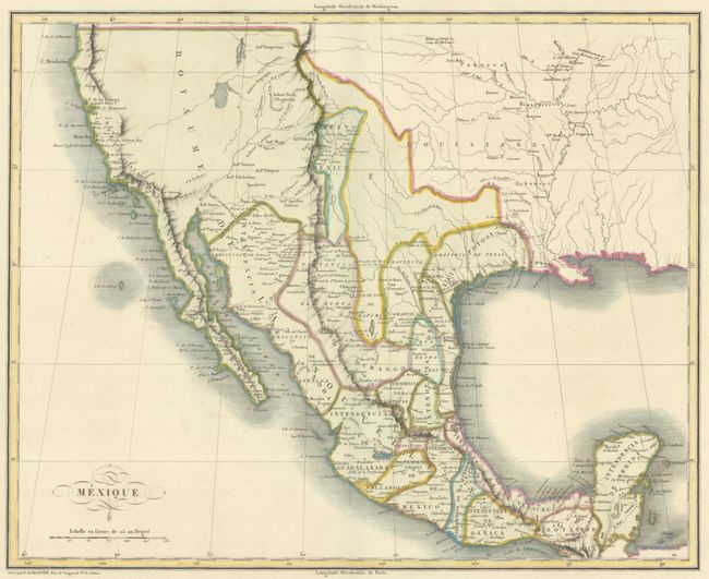
This is the French edition of Carey & Lea's map of Mexico, the Southwest, and Texas. The map extends north to above Cape Mendocino on the coast of California. Mexico is divided into its states. There is good detail of the watershed in the Southwest and Texas. In the Provincia de Texas, Presido Nacogdoch and Presido de Bejer are among the more important settlements shown. Laredo is in neighboring Provincia de Nuevo Santander. This map was issued less than two years after Stephen F. Austin received a grant from the Mexican government to begin colonization in the region of the Brazos River. In the Southwest, Santa Fe and several pueblos including Acoma and Laguna are identified as are the lands of the Apache, Hopi (Moqui), and several other tribes. An unnamed river, originating in L. Timpanagos, crosses the Great Basin on its way to the Pacific at Monte Rey. Engraved by B. de Beaupre. The map is on a full sheet measuring 27.8 x 21.3" with panels of French text, including population figures, at the sides and bottom. Buchon produced the French edition of Carey & Lea's American Atlas. He used a better quality paper and today his maps are generally found in better condition than their American counterparts.
References:
Condition: A
A bright sheet with a minor spot in the map and toning along sheet's edges, well away from map image.