Catalog Archive
Auction 197, Lot 184

Excellent Early American Example of Thematic Flow Map

"Tonnage Chart of Coastwise Commerce, North of San Francisco – California, Including Arrivals and Departures ", U.S. Government

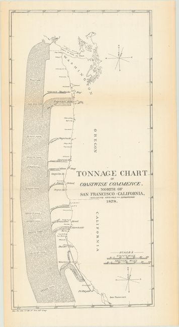
Subject: Western United States

Period: 1878 (dated)

Publication: Sen. Ex. Doc. 59, 46th Congress, 3rd Session

Color: Black & White

Size:
7.5 x 15.6 inches
19.1 x 39.6 cm
Download High Resolution Image
(or just click on image to launch the Zoom viewer)

This is a distinctive early government thematic flow map displaying the volume of maritime trade along the ports from San Francisco to Washington. The map indicates that nearly 1.7 million tons of cargo headed north of San Francisco, with about half going through the Strait of Juan de Fuca, and the other half going to smaller ports in between including the Columbia River and Humboldt River. This chart was used in the planning for harbors of refuge along the Pacific Coast and is an excellent example of the type of economic geography flow map innovated by Charles Minard beginning in the 1840s.

References:

Condition: A

Issued folding with light toning along the sheet edges.

Estimate: $140 - $170

Sold for: $50

Closed on 4/24/2024

Archived