Subject: Southern Italy, Phlegraean Fields
Period: 1586 (dated)
Publication:
Color: Black & White
Size:
20.1 x 15.3 inches
51.1 x 38.9 cm
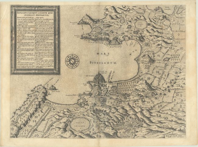
This rare map was based on Mario Cartaro's map of 1584, which was the first published archaeological map of the Phlegraean Fields. The map was the primary source of information on the area until new archaeological surveys were performed during the eighteenth century, and was copied by a number of other mapmakers, including Claudio Duchetti (1586), Nicolas van Aelst (1590), and Francesco Villamena (1620).
The Phlegraean Fields are also known as the Campi Flegrei, and are located in the vicinity of Pozzuoli, a comune of Naples. The map provides an incredible amount of information of the volcanic region and the Greek and Roman ruins in the area. Cumarum (Cumae) was the first Greek colony on the mainland of Italy, and the Roman naval base at nearby Misenum (Miseni) housed the largest naval fleet in the ancient world. Pozzuoli's Latin name Puteoli (little wells) refers to the many hot springs in the area, most notably Solfatara (Sulphitaria), purported to be the home of Vulcan, the god of fire. The map, together with the numbered key, provides information on scores of important sites including Lacus Avernus (Lake Avernus), which was believed to be the entrance to the underworld, the Cave of Dogs (An frum Canum) adjacent to Lake Agnano (Lacus Anianus), Villa Ciceronis (Cicero's villa), several temples, and much more of interest. A lovely wind rose orients north to the bottom right corner of the sheet, and a decorative frame encloses the title and a list of 20 locations within the map. Engraved by Ambrosio Brambilla.
Claudio Duchetti was the nephew and part heir to Antonio Lafreri and the successor to his business. The Lafreri name has become synonymous with some of the greatest Italian map-makers of the 16th century, and gave name to the "Lafreri school," which was a loosely affiliated group of cartographers, mapmakers, engravers, and publishers who worked in the major Italian publishing centers of Rome and Venice, from about 1544 to 1585.
References: Tooley (Italian Atlases of 16th Century) #460.
Condition: B+
A dark impression on a sheet with the watermark of a six-pointed star and the initial "M" within a shield. There is very light toning, minor soiling, and some extraneous creasing along the centerfold and in the top left corner of the sheet.