Subject: London, England
Period: 1801-02 (dated)
Publication:
Color: Hand Color
Size:
22.8 x 16.5 inches
57.9 x 41.9 cm
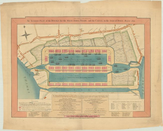
This matching pair of extremely rare plans illustrate the areas in East London that were authorized by Parliament for developing docks and canals. In the late 18th century, dozens of Canal and Navigation Acts were passed by Parliament to assist the burgeoning merchant shipping industry. The first set of docks was named the West India Docks, which opened in 1802 on the Isle of Dogs. The first plan, which was published on 24 August 1801, shows the partially completed West India Docks as well as the proposed additions. Faint dotted lines are included to indicate the roads and areas that no longer existed as they were excavated to create the docks. The current and former landowners are identified in a numbered key. At the beginning of the construction, a time capsule was laid into the foundation of one of the warehouses, and the contents of the time capsule, including the inscriptions are listed below the plan. Apparently, once the West India Docks were complete, they reduced the time required to discharge ships from four weeks to four days.
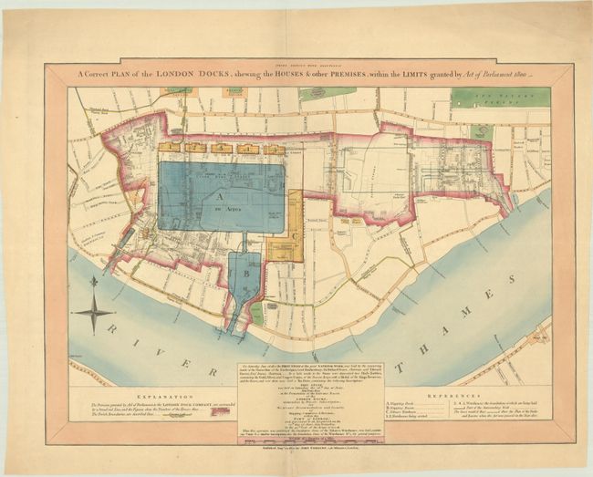
The second plan shows the proposed London Docks, which were built in 1805 in the former Parishes of Wapping, St. George's and Shadwell. This plan was published on 24 August 1802 and outlines the area granted to the London Dock Company in red, and the affected buildings and roads are also shown on the plan. The proposed locations of the docks, basins, and warehouses are identified, noting that the foundations of several of the warehouses had already been laid. The London Docks were also commemorated with a time capsule, and the inscription and contents are also listed below the plan.
The docks became largely obsolete in the mid-20th century, and they were closed between 1960-80. The areas were redeveloped for residential and commercial use over the next several decades, with the West India Docks now known as Canary Wharf.
John Fairburn was a London-based map publisher and geographer who flourished between 1789-1840. He published several maps of London, including London and Westminster, which was amended in 1802 to show the locations of the West India Docks and London Docks. Two of Fairburn's London maps are listed in Darlington and Howgego's Printed Maps of London circa 1553-1850, however his two plans of the docks are not listed. These plans are extremely rare - we were only able to find one example of these plans being offered for sale in the last 25 years. WorldCat only lists examples of the plans in the British Library.
References:
Condition: B+
The maps have nice impressions with full contemporary color on lightly toned sheets with "Russell & Co 1797" watermarks. Centerfold separations at top and bottom, as well as several short edge tears have been archivally repaired on verso. There are a few extraneous creases and some soiling mostly confined to the blank margins.