Subject: World
Period: 1817 (dated)
Publication:
Color: Hand Color
Size:
25.4 x 18.8 inches
64.5 x 47.8 cm
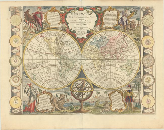
This is an uncommon and striking map of the world in two hemispheres. First published in 1755, this edition has been updated based on new discoveries in the Pacific. In the North Pacific, the coastline of North America has been improved and Alaska is taking shape. Changes have also been made to islands to the northeast of Honshu, however these changes do not improve the accuracy of the depiction of Hokkaido, and several conjectural islands still remain, including Terre de la Compagnie (Company's Land). In the South Pacific, Australia, Tasmania, and New Zealand are now entirely delineated, although the coastlines are still rudimentary. The tracks of numerous explorers fill the oceans, including Cook, Byron, Bougainville, and Furneaux.
There are only a few place names in the interior of North America, including Quebec, Boston, Philadelphia, Charleston, St. Augustine, and New Orleans. Although a few changes have been made to North America since the 1755 edition, such as noting Etats-Unis east of the Mississippi and Louisiane to the west, the British colonies (Colonies Angloises) are still shown along the East Coast. In addition, Lakes Superior, Michigan and Huron are still interconnected. Although the Sea of the West no longer appears, a possible Northwest Passage connects Hudson Bay to the Arctic Ocean north of Canada.
Stunning vignettes representing the four continents fill the corners of the map, each with an allegorical figure presenting a cartouche containing descriptive text, accompanied by a native animal and set in an exotic landscape. Europe includes a horse and symbols of the arts, sciences and war. Africa wears an elephant-head as a hat and stands next to a lion, while Asia holds incense next to a camel. America wears a feathered costume and holds a bow, while a large dinosaur-like creature lays next to an odd-formed human creature that appears to be eating a round piece of fruit. The sides of the map are flanked with columns showing 10 astronomical diagrams of the sun, moon and planetary systems. An armillary sphere sits in the lower cusp of the map, and a grandly decorative title cartouche rests on the upper cusp.
References: cf. McGuirk #49.
Condition: B+
A nice impression on a sturdy, watermarked sheet with several extraneous creases at right.