Subject: Cape Cod, Massachusetts
Period: 1930 (dated)
Publication:
Color: Black & White
Size:
13.1 x 9 inches
33.3 x 22.9 cm
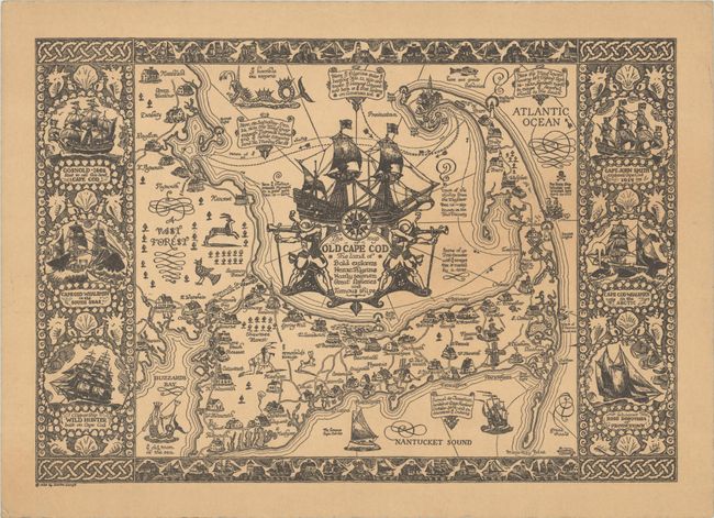
This is the reduced format edition of this fine pictorial map of Cape Cod by Coulton Waugh. At the time of its publication, Laura Guadnazno, a local journalist, described it as "one of the most decorative [maps] ever prepared." It shows roads and towns, with illustrations of local architecture, windmills, lighthouses, and wildlife filling the landscape. In the water are ships and shipwrecks, a sea serpent, and a Neptune-like figure labeled "ye old man of the sea." A large and elaborate title cartouche appears at center in Cape Cod Bay, featuring the Mayflower and a pair of robust, idealized pilgrim marksmen. The map is surrounded by an ornate border incorporating maritime imagery and six vignettes of various ships, including the Gosnold, Captain John Smith's ship, and a couple whalers. Frederick Coulton Waugh (1896 - 1973), the son of painter Frederick Judd Waugh, designed a number of pictorial maps starting in the 1920s, which he sold in catalogs and out of his Ship Model Shop in Provincetown. He drew the popular adventure comic strip Dickie Dare from 1934 to 1944, and again from 1950 to 1957, and wrote The Comics (1947), a pioneering study on the art form. According to a stamp on verso, the map was distributed by United Map Corp., Buffalo, New York.
References: Rumsey #9715.
Condition: B+
A fine impression on an evenly toned sheet.