Subject: Colonial Eastern United States
Period: 1755 (published)
Publication: General Magazine of Arts & Sciences
Color: Black & White
Size:
19.1 x 7.6 inches
48.5 x 19.3 cm
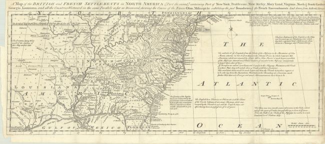
This uncommon map is the second of a two-part map that was issued to accompany a 4-part account of North America. This is the southern sheet, which covers the region from Long Island through northern Florida and extending well west of the Mississippi. It was issued just prior to the French and Indian War and presents a decidedly British point of view with a note at top left stating: "The Bounds of Virginia and New England by Charters May 28, 1609 and Nov. 3, 1620 extending from the Atlantic Ocean to the South Sea out of which our other Colonies were granted." Lord Granville's Limits are also shown extending past the western edge of the map and the Bounds of Carolina stretch well into Florida. The map is filled with other interesting historical and descriptive notes, as well as the locations of Indian tribes, villages, forts, and early settlements.
References: Jolly #GENMAS-69; Sellers and Van Ee #81.
Condition: B+
A crisp impression, issued folding with minor soiling and offsetting. Narrow right margin and binding trim at left, both as issued, with a small chip at bottom left. There are several short separations along the folds and a small hole east of New Jersey that have been closed on verso.