Subject: Cartographic Miscellany, Internet
Period: 1994 (published)
Publication: PC Computing
Color: Printed Color
Size:
35.6 x 23 inches
90.4 x 58.4 cm
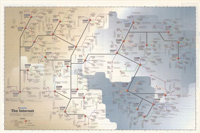
This vintage map was designed for pioneers of a new frontier: the internet. It was the first in a series of a dozen or so road map-like posters published by PC Computing magazine in the mid-1990s as a marketing ploy to set them apart from competitors like PC Magazine and PC World. For this "road map," graphic designer Timothy Edward Downs drew inspiration from classic subway maps as a way to give shape to the abstract concept of the internet. As the legend indicates, he organizes the "rapidly expanding information highway" around servers, with site listings and points of interest radiating from each one. A color-coding system indicates subject matter, broken down into the following categories: Business; Finance & Economics; Reference & Education; Government; and Technology. Servers of note include the library of the University of California, Berkeley (with useful job interview tips); Economic Bulletin Board; the the Internet Tools Summary ("This is the place to go if you want to know anything about the Internet."); U.S.-Japan Technology Management Center; the Executive Branch, U.S. Government; City of Palo Alto World Wide Web Page ("This page shows how cities can effectively advertise (and attract high-tech business) on the Net."); and a List of Commercial Services on the Web. Throughout the map are snippets of Gen X snark; for instance, "How can you resist 'Highlights of 20 Years of Surveys?'" under the Justice Department, or "Use the search tool to find out how it's possible to overspend by a trillion or so" under the U.S. Budget. But the dominant attitude is one of excitement at all the information and possibilities now available at our fingertips.
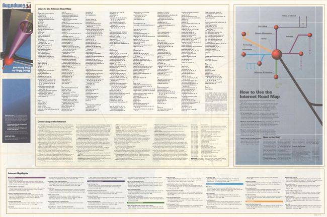
Here is a depiction of the internet right as websites for every day use started to become available to the public - perhaps the earliest widely published map of its kind. It is not unlike looking at Munster's map of the Americas - it is a little primitive, but a new world is definitely starting to take shape. The verso features an illustrated brochure cover, an index, highlights, a how-to on connecting to the internet, and a guide to using the map. Although the PC Computing map posters were printed in large runs, they are scarce on the market today and rarely seen in institutional collections.
References: Rumsey #10444.
Condition: A
Issued folding, now flat, with a few tiny splits at fold intersections and a spot of minor soiling.