Subject: Eastern Asia
Period: 1937 (published)
Publication: Osaka Mainichi Shinbunsha
Color: Printed Color
Size:
42.1 x 29.8 inches
106.9 x 75.7 cm
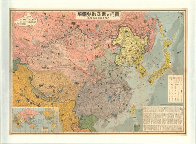
This large, scarce, and ephemeral Japanese propaganda map depicts East Asia at the outbreak of the Second Sino-Japanese War (1937-45), known in Japan as the North China Incident. It was published as a supplement to the January 1, 1937 issue of the newspaper Osaka Mainichi Shinbunsha, just six months prior to the Marco Polo Bridge Incident, often recognized as the inciting incident of the Second Sino-Japanese War. The region is color-coded to show the areas controlled by the Japanese, Chinese, and Soviets. In the northeast, Soviet and Japanese soldiers face one another along the Soviet-Manchukuo border. A tank-shaped explanation box in the upper left provides data on the numbers of Chinese and Soviet troops, fighter planes, and submarines. In the lower right corner, extensive information is provided on the resistance against Japan, the establishment of Manchukuo, etc. An inset map shows the region in relation to the world. The map is presented in the pictorial style with cartoonish depictions of plants, animals, and natural resources that are a rather bizarre addition to the map. A fascinating historical map that captures the contemporary tensions in the region just as they were about to break into the Second Sino-Japanese War and World War II. This example has been professionally mounted on heavy linen.
References: Rumsey #11108.
Condition: B+
Issued folding, now flat and mounted on heavy linen. There are few small, unobtrusive abrasions and some fold separations that are all now archivally backed. There is some minor soiling along the sheet edges.