Subject: Massachusetts
Period: 1930 (dated)
Publication:
Color: Printed Color
Size:
38.2 x 26.3 inches
97 x 66.8 cm
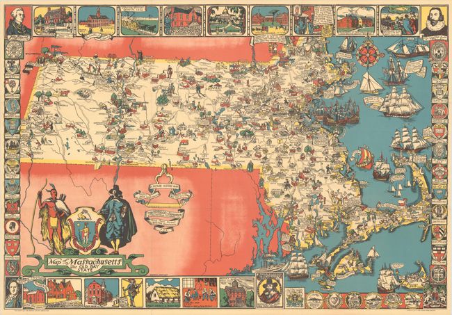
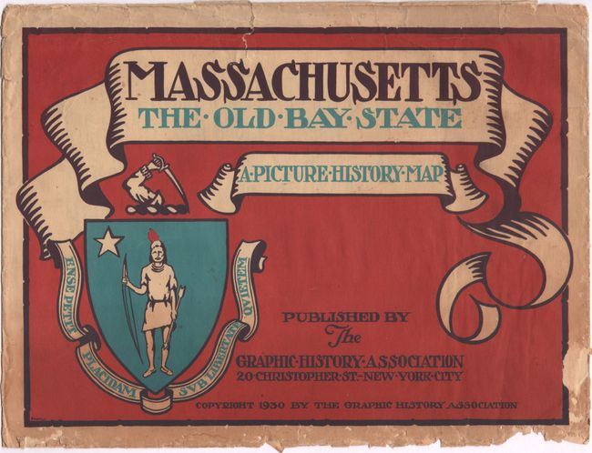
This stunning "Picture History Map" of Massachusetts was designed by Elizabeth Shurtleff. Published during the peak of the Colonial Revival movement, the map was part of a wave of pictorial maps focused on the early history of America. The state is dense with charming illustrations of notable historical events and people: Bartholomew Gosnold, the colony at Plymouth, Captain Kidd, John Eliot preaching to the Indigenous, the Salem Witch Trials, the Mohawk Trail, "the shot heard round the world," Paul Revere's Midnight Ride, Shays' Rebellion, and much more. Towns are noted with the date of their founding. The waters are filled with notable ships, including the Viking Thorwald Erikson's ship, the Mayflower, the Pequod ("Have you seen Moby Dick, Captain Ahab!!"), and the Darmouth, depicted with its cargo of tea being dumped into Boston Harbor. Surrounding the map are historical vignettes, the armorial crests of the state's various educational institutions, and portraits of John Hancock, John Winthrop, Benjamin Franklin, and Charles I. A large title cartouche features an Indigenous man and a pilgrim flanking the state seal. Published in Boston by the Graphic History Association, a company dedicated to the publishing of historical maps founded by Shurtleff and Helen McMillin. Lithography by the Tudor Press. "Approved by Tercentenary Conference of City and Town Committees, Inc." The map was issued in two variants, one printed in three colors and the other in four; this is a desirable example of the latter, with a bold and vivid red-blue-green-yellow color scheme. It is accompanied by the original illustrated envelope and a very challenging history quiz that underlines the map's intended educational purpose.
Elizabeth Shurtleff (1890 - 1968) was a painter and artist born in Concord, New Hampshire and educated at Boston Museum School of Fine Arts. From 1926 to 1930, she designed a group of pioneering pictorial maps, published the Graphic History Association. She was a key figure in the cluster of women mapmakers who shaped the aesthetics and conventions of pictorial cartography in the early 20th century.
References: Hornsby (Picturing America) pp. 22-23, 90-91; Rumsey #8518.
Condition: B+
A bright and colorful example, issued folding, with a few small holes in the bottom right quadrant of the map only visible when held to light. There are chips and edge tears along the edges of the accompanying envelope.