Subject: Georgia Coast
Period: 1780 (dated)
Publication: The Atlantic Neptune
Color: Hand Color
Size:
29.4 x 23.3 inches
74.7 x 59.2 cm
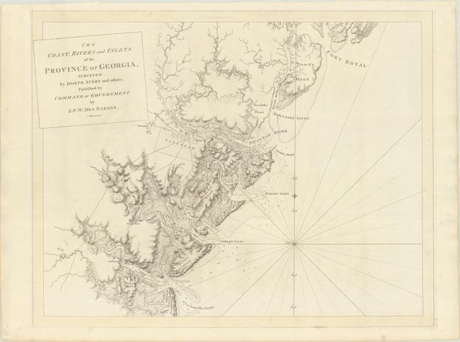
This important and rare Revolutionary War-era chart is based on a survey by Joseph Avery, who was commissioned by the Trustees of the Colony of Georgia. Avery conducted his survey between 1741 and his death in 1744, and succeeded in finding a more navigable water route to Savannah, made recommendations on suitable locations for dock yards and settlements, and divided the land into plots and plantations to be granted to settlers by the Trustees. Avery presented his surveys to the Trustees, but they were not published until Des Barres incorporated them into his charts for The Atlantic Neptune.
This chart follows the Atlantic coastline from Port Royal Sound to St. Catherine's Island with excellent detail of rivers, coastal islands, marshes, shoals, and depth soundings. Only the towns of Savannah, Newington, Hardwick and Sunbury are shown, however there are numerous land plots identified, mostly along the rivers. Early roads are also depicted, including the road leading to the important Georgia settlement of Ebenezer. Because this chart was so detailed, it was distributed to British Officers during the Revolutionary War, although not until after the Siege of Savannah, which occurred in September-October 1779. The British succeeded in retaining control of the city during the siege, holding on to it until near the end of the war.
Joseph Des Barres was a military engineer with the British Royal American Regiment. At the conclusion of the French and Indian war, he surveyed the coastlines of Nova Scotia, Newfoundland, and the Gulf of St. Lawrence. Upon his return to London in 1774, the Royal Navy assigned him the task of producing an atlas of new, accurate sea charts of Britain's empire in North America. In addition to his charts of the Canadian waters, he compiled the manuscripts of British cartographers in the American Colonies, Jamaica and Cuba and produced one of the most important sea atlases of the era, The Atlantic Neptune, published between 1777 and 1781. It contained the first systematic survey of the east coast of North America, consisting of four volumes and over 250 charts and views. All the charts were immensely detailed, featuring both hydrographical and topographical information.
This chart is very rare on the market. We have found only 3 examples offered at auction and 2 examples offered by dealers in the last 30 years. This chart has been pale-wash-tinted with pale yellow borders, as issued.
References: Sellers & Van Ee #1598; Shirley (BL Atlases) MDES-1g, Part III #10. Nebenzahl 79; Stevens & Tree 13b
Condition: A
A crisp impression with contemporary wash color on a bright sheet with "JB" and "JBates" watermarks and minor marginal soiling.