Subject: Colonial Southeastern United States
Period: 1661 (published)
Publication: Arcano del Mare...
Color: Black & White
Size:
15 x 18.9 inches
38.1 x 48 cm
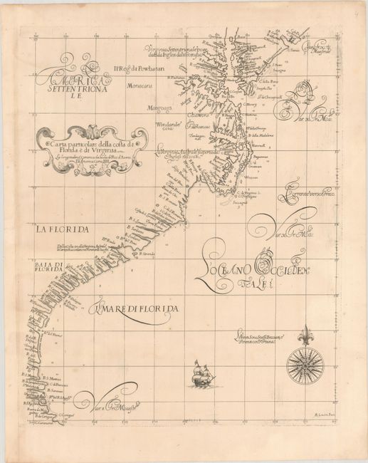
This remarkable sea chart is the earliest printed chart to focus on the Southeastern coastline of the United States, and is also the first chart to note the prevailing winds and ocean currents. It depicts the coastline from Delaware Bay to Cape Canaveral, with detail of the sand banks, rocks, reefs, and depth soundings, noting the river inlets along the coast. The northern portion of the map, and in particular the representation of the Virginia and Carolina Sounds, is based on the maps by John White and John Smith. Jamestown is located on the northern shore of the Rio del Re (James River) and the Rappahannock River is labeled R; Toppahamock. Further south, the nomenclature was taken from both Jodocus Hondius' Virginiae Item et Floridae and early Spanish sources. The chart is elegantly engraved with fine calligraphy, a bold title cartouche, a sailing ship, and a compass rose by the Florentine craftsman Arnoldo Lucini. This is the second state with "Lo.6o." added to the title cartouche.
Robert Dudley was the first Englishman to produce a sea atlas, Dell Arcano del Mare (Secrets of the Sea). Dudley, a skilled mathematician and navigator, was exiled from England and settled in Florence where his atlas was published. He introduced a totally new style for sea charts in the atlas with only lines of latitude and longitude and no rhumb lines. The charts were meticulously compiled from original sources and were both scientific and accurate for the time. This important atlas was the first sea atlas of the whole world; the first to use Mercator's projection throughout; the earliest to show the prevailing winds, currents and magnetic deviation; and the first to expound the advantages of Great Circle Sailing. In an introductory leaf found in one copy in the British Library, the engraver (Lucini) states that he worked on the plates in seclusion for twelve years in an obscure Tuscan village, using no less than 5,000 pounds of copper for the printing plates. It was only issued in two editions and the maps are rarely seen on the market.
References: Burden #280; Cumming (SE) #45; Shirley (BL Atlases) M.DUD-1b.
Condition: A
A sharp impression on a bright sheet with a couple of tiny, unobtrusive spots and minor toning at far left.