Subject: Colonial Mid-Atlantic United States, Revolutionary War
Period: 1776 (dated)
Publication: The North American Atlas
Color: Hand Color
Size:
22.6 x 28.1 inches
57.4 x 71.4 cm
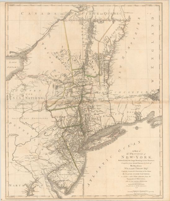
This early Revolutionary War map was published shortly after the signing of the Declaration of Independence and served as one of the most up-to-date maps of the region at the time. It is based on two important actual surveys by Claude Joseph Sauthier and Bernard Ratzer. Sauthier was the assistant of William Tryon, who is noted in the title of the map and was the last British governor of the province of New York. Sauthier created a manuscript map, Chorographical Map of the Province of New-York, that focused on the settlement within the province, as well as land grants, county boundaries, and boundaries with neighboring provinces. Bernard Ratzer was a Lieutenant in the British Army and served as a cartographer. He created an important manuscript map of lower Manhattan and parts of Brooklyn and New Jersey, which was published by Jefferys and Faden in 1776. Ratzer also created a manuscript map of New Jersey that focused on the boundary between New York and New Jersey, which had been long contested. Ratzer's map of New Jersey wasn't published until 1777 (also by Faden). This map combines the information from Sauthier and Ratzer's work.
It includes the present-day states of New York, New Jersey and Vermont with parts of adjoining colonies and Canada. Includes Martha's Vineyard, Long Island, Boston, northern Chesapeake Bay, Annapolis, Dartmouth College and settlements along the Connecticut River, and extends north to show Montreal. The map provides a fascinating and detailed look at the towns, villages, military posts and forts, manors, roads, churches, rivers and ferries at the beginning of the Revolutionary War. Vermont is still part of New York, although it would secede from the state the following year. Western New York is noted as "Country of the Six Nations."
Of key importance on the map is the disputed line of partition between New York and New Jersey. Although New Jersey was separated from New York in 1664, the boundary between the two provinces was constantly in controversy. The map shows the "Partition Line Ordered in 1769," which was settled by a royal commission after new survey work was completed. The division between East and West New Jersey is also shown.
This map appeared in some issued of Faden's The North American Atlas.
References: cf. Schwartz & Ehrenberg, pp. 187-88; Sellers & Van Ee #1047.
Condition: B+
A crisp impression with contemporary outline color on a bright sheet, issued folding with light toning along the horizontal fold and minor foxing. Trimmed at top and bottom with loss of the publisher's imprint at bottom, as is commonly found.