Subject: North America, Civil War
Period: 1862 (dated)
Publication:
Color: Hand Color
Size:
42.3 x 47 inches
107.4 x 119.4 cm
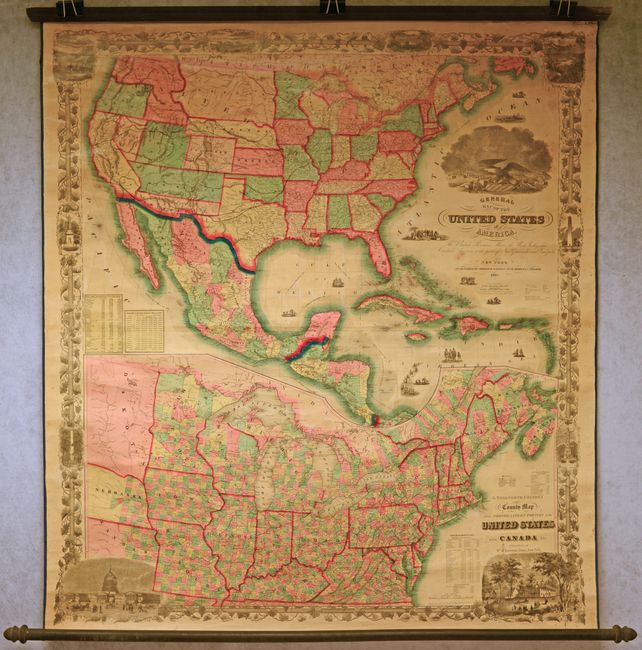
This rare Civil War-era wall map offers a grand and comprehensive view of the continent. Its depiction of the United States features a fascinating configuration of territories in the ever-changing American West. Present-day Oklahoma is Indian Territory, and the panhandle of Nebraska Territory extends over Colorado to the border of Utah. North of Nebraska is a vast Dakota Territory. Washington Territory is shown in its 1859 configuration, before it ceded its eastern portion to Idaho and Nebraska territories. Confederate Arizona appears south of a horizontal strip-like New Mexico Territory. Railroad routes, including the proposed Pacific railroad route, are boldly highlighted, as are the Oregon Trail, Pony Express Route, and Overland Mail Route. Mexico is divided into its states. Above the title is a large vignette featuring and a mighty bald eagle and other American symbols. Smaller vignettes in the Atlantic include a whaling scene and a meeting between colonists and Indigenous people. Two tables at bottom left show the square miles and population of the free states, slave states, and territories and the population of the slave states in 1850 and 1860. Published by Phelps & Watson. Drawn by George Woolworth Colton and engraved by John M. Atwood.
Below the main map is a huge inset titled G. Woolworth Colton's New County Map of the Northeastern Portion of the United States with Canada Etc. spanning from Kansas to Prince Edward Island. As the title suggests, it delineates counties, including ones newly established along the eastern edges of Kansas and Nebraska. The map is surrounded by an elaborate decorative border that was designed and engraved by W.S. Barnard. It incorporates 10 vignettes, including Willamette Falls, Oregon, the Connecticut River Valley, the U.S. Capitol, and Mount Vernon. Backed in linen, attached to original rollers with ribbon edging.
References:
Condition: B+
Contemporary color. The map is mostly clean and bright and the varnish has not toned. There is light foxing and a few small stains. Original rollers are intact.