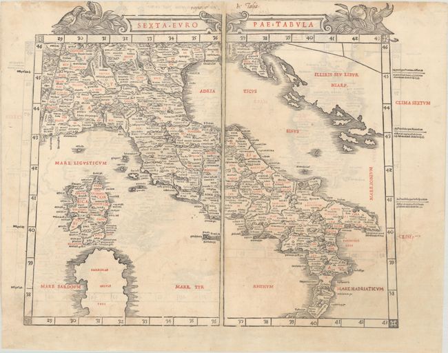
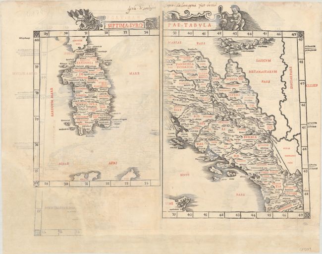
Subject: Italy, Sardinia & Western Balkans
Period: 1511 (published)
Publication: Claudii Ptholemaei Alexandrini Liber Geographiae cum Tabulis…
Color: Printed Color
Size:
21.5 x 16.6 inches
54.6 x 42.2 cm
This rare and distinctive map of Italy, from the 1511 edition of Ptolemy's Geograhia, is an extremely early example of 16th century Venetian cartography and one of the earliest maps obtainable by today's collectors. This Latin edition of Ptolemy was the first published in Venice, by Jacobus Pentius de Leucho, and was the first atlas to use two-color woodblock printing. The maps were printed in black with place names and headings printed in red ink by means of type set into the woodblock and applied with a second strike of the plate. The text was based on a Latin translation by Jacobus Angelus, with revised maps by Bernardus Sylvanus. Little is known of Sylvanus, a native of Southern Italy, although he is believed to have been a monk. Realizing that Ptolemy's maps were outdated, Sylvanus set out to update them with modern information, often from contemporary manuscript sources. The resulting effect was an unusual hybrid of classical and modern information. Sylvanus also introduced a new "modern" world map, depicted for the first time in a distinctive cordiform (heart-shaped) projection, which was adopted by several later cartographers and used for a number of important 16th century maps.
This sheet includes a map of Italy on recto and maps of Sardinia and part of the Dalmatian coast on verso. The maps are vigorously engraved with undulating mountains, bold rivers and numerous ancient place names. The title cartouche on the map of Italy is flanked by birds eating pomegrantes, while the cartouche of the maps on verso features a cherub with an urn. With the exception of the two world maps, the maps from the Sylvanus atlas were printed in such a way that the left-hand side of each map was printed on the verso of the right-hand side of the preceding map. Thus the complete maps from this atlas that are sold on the contemporary market are now joined from two sheets, with two unrelated half maps on the verso. Printed on two sheets, joined.
References: Mickwitz & Miekkavaara #204-7 & #204-8.
Condition: B
A nice impression on a sheet with an "X" watermark, light soiling, and old manuscript ink notations in the top margin on both recto and verso. There are professional repairs to a number of short tears and several small holes in the image. The sheet has been remargined at bottom, and a chip encompassing the sea in the bottom right corner of the map has been professionally repaired with the image skillfully replaced in facsimile.