Subject: Western Europe
Period: 1712 (dated)
Publication:
Color: Hand Color
Size:
39.8 x 24.5 inches
101.1 x 62.2 cm
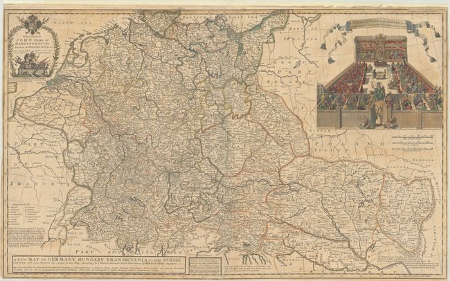
This large-format map, printed and joined on two sheets, covers the entire German Empire from present day Netherlands and Belgium east to Hungary and Romania. The map is filled with detail including the locations of towns, abbeys, universities, rivers and mountains in profile. The map also shows the route of the Duke of Marlborough into Germany in 1704 during the War of the Spanish Succession, and a dedication cartouche at top left shows the Duke on horseback crushing his rivals. Above the map at right is a large vignette titled The General Diet of the Empire..., which shows members of both church and state from across the German Empire in assembly. The meeting is protected by a woman named "Defence of Liberty" who is perched above the doorway marked the "Liberty of Germany."
References:
Condition: B
Full contemporary color on lightly toned sheets with a bit of offsetting and light soiling. Trimmed close to neatline all around the map. There are a few short edge tears along the sides of the map that have been closed on verso with paper tape and linen, and the top edge of the sheet has been reinforced with linen.