Catalog Archive
Auction 194, Lot 291

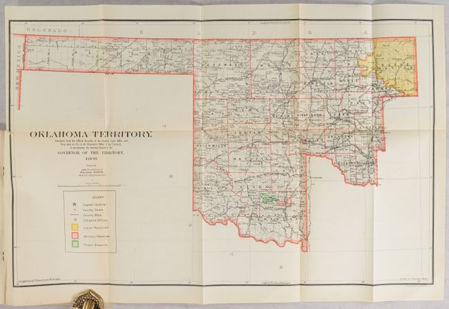
"[Map in Report] Oklahoma Territory. Compiled from the Official Records of the General Land Office... [in] Report of the Governor of Oklahoma to the Secretary of the Interior...", General Land Office

Subject: Oklahoma

Period: 1906 (published)

Publication:

Color: Printed Color

Size:
22.1 x 13.9 inches
56.1 x 35.3 cm
Download High Resolution Image
(or just click on image to launch the Zoom viewer)

This is an updated version of the General Land Office map first published in 1898. It shows the configuration of Oklahoma without Indian Territory, which at this time was under consideration for separate statehood (Sequoyah). The map locates the Osage Nation in the northeast corner of the territory, military reservations, forest reserves and U.S. Land Offices. Guthrie is noted as the capital. The following year in 1907, Indian Territory was absorbed by Oklahoma and the two became a single state. Drawn by Charles J. Helm under the direction of Frank Bond. The map is still bound into the rear of the 154-page Report of the Governor of Oklahoma.

References:

Condition: B+

The folding map has light toning, minor offsetting, and a tiny binding tear into the left border. Report text is very good. Wrapper has light wear and is starting to detach from the spine.

Estimate: $160 - $190

Sold for: $120

Closed on 9/13/2023

Archived