Subject: Alaska
Period: 1959 (dated)
Publication:
Color: Printed Color
Size:
43 x 31.6 inches
109.2 x 80.3 cm
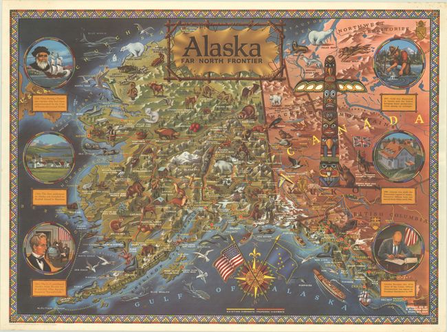
This appealing and graphic map was created to celebrate Alaska's statehood. In addition to the topography, cities, rivers, lakes, mountains, and existing and proposed highways of Alaska and western Canada, the map is teeming with illustrations of the wildlife of the region (including sea otters, timber wolves, and grizzly bears), several prospectors, bush planes, a train, a "Mountie", a massive totem pole, and various other local phenomena. Six circular vignettes run along the left and right sides of the map, depicting moments from the state's history, including Vitus Bering's discovery of the area, Seward's Folly, and President Eisenhower signing Alaska into statehood. The title of the map appears on a stretched piece of animal hide and a compass rose at bottom features the American flag crossed with Alaska's state flag. Surrounded by a beadwork-style border. Illustrated and published by R. Klengston "Kleng" Rude. This example is accompanied by the original cardboard shipping tube with decorative address label from Rude's studio Alaska Arts to the map's previous owner in McKinley, Minnesota.
References:
Condition: A
A bright and colorful example with tiny pinholes and light spots confined to the blank margins. The map is tightly rolled and does not lay flat on its own.