Subject: Eastern United States
Period: 1797 (dated)
Publication:
Color: Hand Color
Size:
9.5 x 7.3 inches
24.1 x 18.5 cm
By the time of the Revolutionary War, the practice of awarding bounty land as an inducement for enlisting in the military had been a long-standing practice in colonial North America. Besides imperial bounty land grants, both colonial and municipal governments routinely compensated participants in and victims of military conflicts with land. Land was a commodity in generous supply, and governments seized upon its availability for accomplishing their goals.
Following this tradition, the Revolutionary governments used bounty land grants in their struggle for independence from Great Britain. They generally offered free lands in exchange for military service, provided they were victorious in their struggle. Thus, bounty lands were an effective technique for enrolling support for the war and encouraging re-enlistments. Generally the bounty lands were located on the western frontier, which provided another benefit to the government. Populating the frontier with citizens skilled in defense offered the best prospect in enticing other settlers to join them, thus eventually increasing the tax rolls.
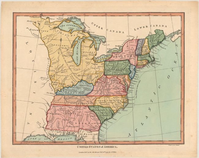
An attractive small map of the nascent United States that extends to the Mississippi River. Georgia includes present-day Alabama and Mississippi and Florida is divided between East and West. Above Georgia is Tenassee Government, the state of Kentucky, and a huge, unnamed Northwest Territory which would be "divided into 10 states by a Resolve of Congress 1784." Several bounty land grands are identified on the then-frontier including lands reserved for Virginia troops, North Carolina troops, New Jersey Company, Illinois Company and Wabash Company. Also located are the Seven Ranges and Ohio Company above the Ohio River, and Indiana Company in present-day West Virginia. Engraved by Samuel Neele.
References: Phillips (Maps) p. 872.
Condition: A
A crisp impression on a clean sheet with a few spots of foxing in the margins.