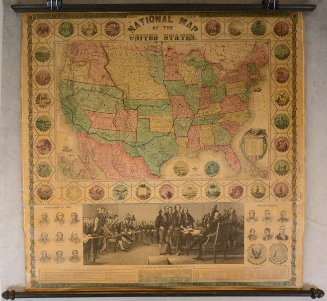
Subject: United States
Period: 1859 (dated)
Publication:
Color: Hand Color
Size:
35.8 x 38 inches
90.9 x 96.5 cm
This attractive wall map presents the United States with evolving territorial configurations in the west, and was around the onset of the Civil War. With Oregon having just achieved statehood, Washington Territory is shown in its unusual inverted "L" configuration next to a massive Nebraska Territory, which extends east to the Missouri River. To Washington's south is Utah Territory in its largest extent and a large New Mexico Territory with Arizona occupying its southern half - an early presentation of what would become the Confederate Territory of Arizona. To the east of Utah Territory is the elongated Kansas Territory including present-day eastern Colorado. Dakota Territory (established 1861) also makes an early appearance, wedged between Minnesota and the Missouri River. Two possible transcontinental railroad routes are prominently depicted in blue - one from Lecompton, Kansas west to Sacramento (central route) and another from Jefferson City to San Francisco (southern route). The map is surrounded by an elegant presentation of the state seals and a scene depicting the Signing of Declaration of Independence appears below the map image.
Given the appearance of both Dakota Territory and Arizona Territory occupying the southern portion of New Mexico Territory, this map was likely published circa 1861.
References:
Condition: B+
The map is overall mostly clean and crisp with even light toning and a bit of foxing. There is a 2" tear above the title in a blank area, a small hole in a blank area of the upper image, and some areas of minor loss in the side margins that occasionally touch the decorative border. Rollers are present and attached.


