Subject: North America
Period: 1966 (dated)
Publication:
Color: Printed Color
Size:
20.8 x 25.8 inches
52.8 x 65.5 cm
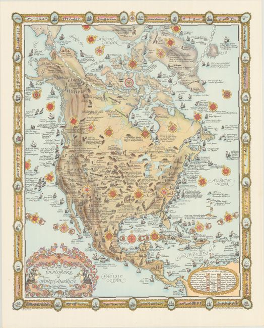
This magnificent pictorial map of North America by Peter R. Furse is teeming with illustrations of the explorers who defined the continent. Ships fill the waters with accompanying dates, the name of the explorer, and a note on their discovery. On land, various expeditions map the terrain: there is Coronado and his men in Mexico and the Southwest; Lewis and Clark snaking up the Missouri; and a ring of prospectors exploring the Yukon. An ornate title cartouche appears at bottom left. The legend at bottom right identifies the nationalities of various flags. The Arctic Circle is playfully depicted as a string of polar bears, while the Tropic of Cancer is a series of crabs. Several compass roses complete the composition. The decorative border incorporates sailing ships and vignettes of explorers trudging across the landscape. Published by Maclean-Hunter Publishing Company Limited.
This map is from the estate of artist and cartographer Peter R. Furse (1901-70). Furse was born 1901 in Farnham, Surrey, England. During World War I, he enlisted in the Royal Navy. He worked as a cartographer and graduated from Emmanuel College, University of Cambridge, in 1922. He moved to Africa and was stationed in Cape Town, South Africa during World War II. It was during his time in Africa that Furse began to make pictorial maps. His family relocated to North America, eventually settling in New Brunswick, Canada in 1962. Once there, he became an active member of the "Hampton Group" artists' community and continued to work on his art until his death in 1970. Furse's terrific style mixes a 20th-century graphic sensibility with an uncommon elegance that hearkens back to the aesthetics of previous centuries of mapmaking.
For other maps by Peter Furse, see lots 102 and 106.
References: Rumsey #15287.
Condition: A
Near fine with a minor crease in the top right blank margin.