Subject: Colonial North America
Period: 1704 (dated)
Publication:
Color: Black & White
Size:
20.5 x 17 inches
52.1 x 43.2 cm
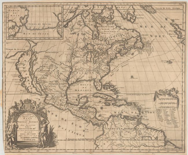
Louis de Hennepin, a Franciscan missionary, accompanied LaSalle in the explorations of the Upper Mississippi. After LaSalle returned for additional supplies, Hennepin and his party were captured by Sioux Indians. While traveling with the Indians, Hennepin discovered the falls where Minneapolis now stands, and named them St. Anthony Falls, in honor of his patron saint. Rescued in 1681 by Sieur du Luth (Duluth), Hennepin returned to Europe where he published accounts of his journey with some embellishments, including a claim that he explored the Mississippi to its mouth. Despite this claim being discredited, his maps are still important for their depiction of the Great Lakes region. This handsome map depicts the island of California on the Sanson model. The Mississippi River nearly bisects the continent and empties into the Gulf of Mexico too far to the west. There are several spurious rivers in the west including the R. de Tecon that has its headwaters in same mountains as the R. Massourite (Missouri) and flows along a mountain range noted as the location of the mythical Cibola. Shipping routes from Europe to the Americas are noted through the Atlantic Ocean. An inset features a large landmass, Terre de Iesso, that spans the region between Asia and North America. The map is embellished with a decorative title cartouche dedicated to William III of Britain, which is balanced with a decorative key listing the European possessions. This example is the fourth state with the imprint of Pierre van der Aa. Printed on two joined sheets, as issued.
References: Burden #738; Goss (NA) #47; McCorkle #697.2; McLauglin #124-2; Tooley p. 125 #59; Wagner (NW) #452.
Condition: B
A dark impression, issued folding on a sheet with a small "C.B." watermark. There is minor toning, some tiny spots of foxing, and a few tiny separations along the folds. There is a binding trim at left that extends to the neatline, with partial loss of the neatline at bottom. A binding tear that enters 5" into the image at left has been archivally repaired on verso.