Subject: Atlases
Period: 1745 (circa)
Publication:
Color: Hand Color
Size:
11.4 x 8.9 inches
29 x 22.6 cm
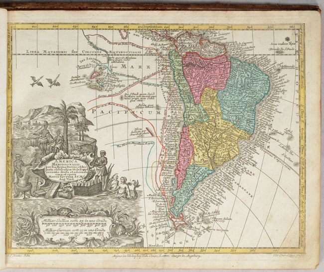
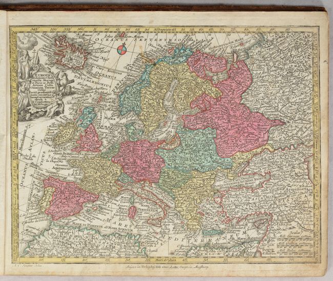
This atlas includes 20 maps by Lotter, some drawn by Seutter. In addition to the world and five continents, there are maps of Spain & Portugal, France, Italy, Britain, Low Countries, Central Europe, Hungary, Balkans, Scandinavia, Baltic States, Russia, Middle East, Holy Land, and an inset map of Germany on a page with tables of distances between key European cities. Of key interest are the following maps:
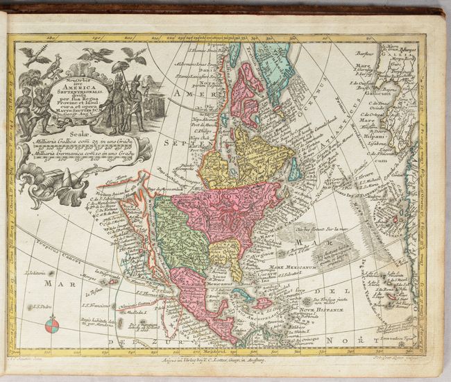
Nova Orbis sive America Septentrionalis. A superb small map with California as an island on the second Sanson model, showing two bays on the north end of the island. The island is also very narrow in the center, almost becoming two islands, a theory proposed by Father Luis Velarde. The map is densely covered with place names, and the northern extremes are strangely elongated. The large title cartouche, surrounded by Native Americans and birds conveniently obscures the northwest coast with the exception of a portion of the Terra Esonis incogn.
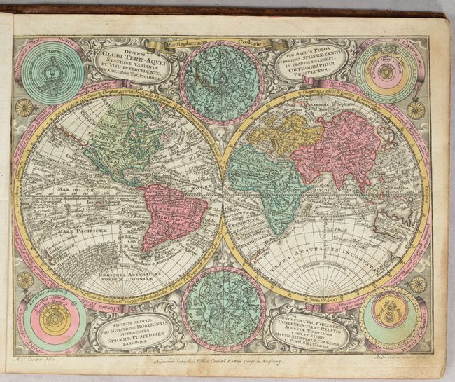
Diversi Globi Terr-Aquei. This is the reduced edition after Seutter's larger and beautiful map that is considered one of the most graphic 18th century world maps. California is an Island and Japan is shown in a bizarre shape that incorporates the fictional Terra Yedso. An elongated stretch of land, Terra Esonis, extends from Japan to California. The map is filled with detail including the tracks of several explorers. Between the hemispheres are celestial charts of the northern and southern skies, while diagrams of the solar system based on the theories of Ptolemy, Copernicus, Descartes and Tycho Brahe fill the corners. It is set in a richly engraved background of clouds with numerous wind heads and four cartouches. Engraved by Andrea Silbereisen.
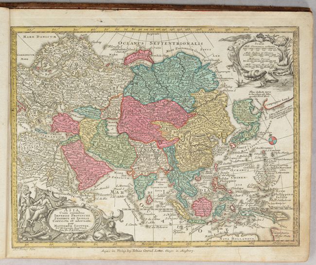
Asia cum Omnibus Imperiis Provinciis, Statibus et Insulis. Charming reduced version of this German map covers the continent and the East Indies. Terra Yedso is represented here as a large landmass to the north of Japan (Honshu) and linked by a narrow causeway. Compagnie Land is shown to the east and marked with a notation that is was discovered by Don Iean de Gama. There is no Kamchatka peninsula and Nova Zembla appears to be a peninsula rather than an island. The cartouche represents the exotic East with people and animals.
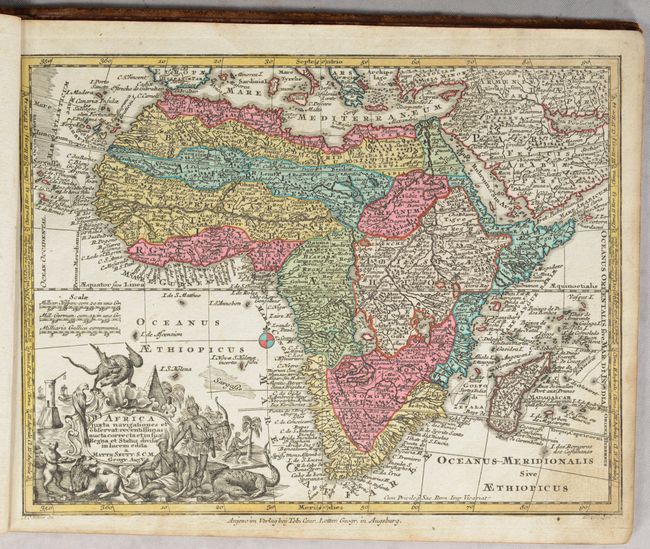
Africa Juxta Navigationes et Observat. Handsome map displaying Seutter's strong style. The map is packed with detail - much of it fictitious. The Nile is shown not only originating in twin lakes, but also continuing further south nearly to the tip of the continent. A lake joins the Senegal and Niger Rivers. The large, cartouche is beautifully engraved and surrounded by natives and exotic animals including a large winged dragon.
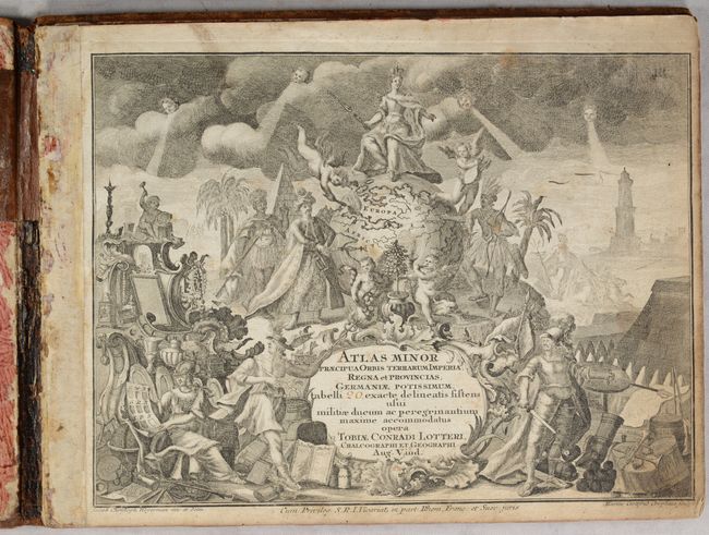
The superb title page is centered on a large globe showing the Eastern Hemisphere. The globe is surrounded by figures representing each of the four continents, with Europa on top. The remainder of the scene is filled with mythical figures (including Neptune, Athena, and Mercury), a soldier surrounded by weaponry, cherubs, and trade goods. Drawn by Jacob Christoph Weyerman, engraved by Martin Gottfried Crophilus. The engraved title leaves a blank space for the number of maps to be entered in manuscript, as the Atlas Minor was issued with a varying number of maps.
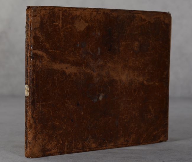
Oblong octavo with 20 maps and a title page. There is no list of maps, but the atlas is complete according to Phillips, with the exception of the front free-endpaper. Hardbound in full brown leather, although the covers are detached from the text block.
References: McLaughlin #221; Phillips (Atlases) #3492; Yeo #133.
Condition: B+
The condition code is for the maps, which are in full contemporary color with light soiling, mostly just at bottom right where the pages were turned. The title page has moderate soiling and is toned at right. The back free-end paper has old manuscript writing and drawings. The maps and title page are still bound together, although the covers are completely detached. The front free end-paper is lacking. The covers are well worn with scuffs, stains and bumped corners. There is an old paper stamp on the spine.