Subject: United States, Gold
Period: 1851 (dated)
Publication:
Color: Hand Color
Size:
41 x 28 inches
104.1 x 71.1 cm
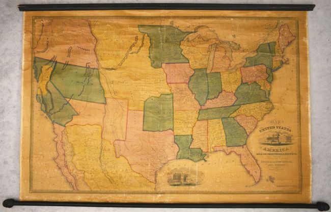
This scarce wall map was issued at a time when many territorial borders were at their most unique configurations. Utah is a large territory that includes all of Nevada and part of western Colorado, with both a Mormon Fort and "Mormons" noted along the shores of the Great Salt Lake. New Mexico is in its largest configuration, extending between Texas and California. In California, an oversized Gold Region is prominently depicted spanning from Monterey all the way north to Mount Shasta and erroneously locates New Helvetia along the coast. Oregon Territory extends to the Continental Divide and encompasses present-day Washington. Nebraska extends from Indian Territory to the Canadian border and includes today's Montana, Wyoming, Kansas, and about half of the Dakotas. A note describes the western portion of this territory as "traversed by numerous herds of buffaloes and wild horses and by a few roving tribes of Indians. Occasional bands of white hunters and trappers range this country for furs." Texas is slightly elongated, but presented in its final state boundaries with development extending from the Gulf Coast west to Austin and San Antonio. The map is decorated by illustrations of the Capitol Building and White House and surrounded by a decorative border. Backed with original linen and original rollers are intact. Published in Hartford, Connecticut. This map was first published in 1833 by Reed & Williard. In 1842, the imprint changed to Reed & Barber with various editions occurring until approximately 1855. Wheat references both the 1849 and 1850 editions of this map.
References: cf. Wheat (TMW) #632 & 689; cf. Wheat (Gold) #114.
Condition: B
The map is generally clean and bright with minimal darkening of the varnish. There are some small dampstains in the lower third of the image and one along the left border. Numerous cracks and creases are visible throughout, with a few of the larger cracks being reinforced on verso with archival materials. There are minor chips and abrasions along the left and right sheet edges in the blank margins. Rollers are present and intact.