Subject: Western Hemisphere - America
Period: 1595 (published)
Publication: Le Relationi Universali
Color: Black & White
Size:
9.7 x 6.8 inches
24.6 x 17.3 cm
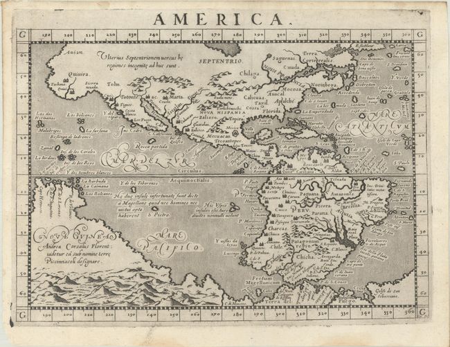
This early map of the Americas is based on Ortelius and D'Anian. The Sierra Nevadas are named and Quivira appears both as a region and a large city in North America. The towns of Marta, Zalisco, and Culuacan are noted near present-day New Mexico. Another large city labeled Totonteac is shown at the top of the Mar Vermeio (Gulf of California). A wide St. Lawrence River has its headwaters in a tiny lake in the region named Saguenai, and there are no Great Lakes. The names Norinbega for New England, Mocosa, and Apalche are on the eastern seaboard. Off the coast, the imaginary islands of Frislant, Dos Demonios, Sept Cites, and St. Brendain are shown. South America is shown with a bulging western coast from Ortelius, while an outsized La Plata River plunges into the continent. A massive Tierra del Fuego fills the bottom of the map and is connected to an even more massive Nova Guinea, which carries a notation referring to Andrea Corsali, a 15th-century Florentine explorer who described and named the Southern Cross. This is the first state with no line encircling the continent, engraved by Girolamo Porro, although his imprint does not appear on this state. Blank verso.
References: Burden #86.
Condition: A
A dark impression with a few miniscule wormholes that are only visible when held up to light and minor dampstaining in the blank margins.