Subject: North Atlantic, Cuba, Puerto Rico, Philippines
Period: 1898 (dated)
Publication: The Boston Sunday Herald
Color: Printed Color
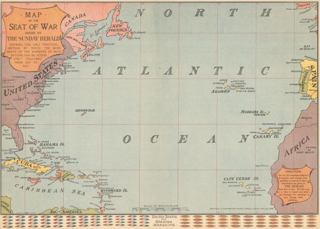
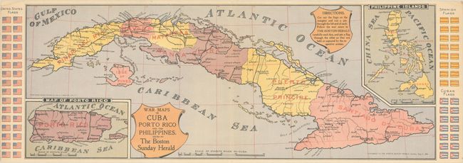
These two Spanish-American War maps were published as supplements to The Boston Herald in the early stages of the war. They were designed to allow the reader to visually follow the events of the war by moving small pieces on the maps.
A. Map of the Seat of War Issued by the Sunday Herald Showing the Only Practical Method by Which the Movements of Warships of Both Nations Can Be Accurately Followed Day by Day (19.9 x 13.4"). Covers the entire North Atlantic Ocean including the eastern United States, Caribbean, Spain, and western Africa. Featrues the names of numerous U.S. and Spanish warships at bottom which could be moved around on the map "as reports of their movements are given in The Herald." Issued as a supplement to the April 24, 1898 issue.
B. War Maps of Cuba Porto Rico and the Philippines. Issued by the Boston Herald (25.3 x 9.7"). A detailed map of Cuba with insets of Puerto Rico and the Philippines. Flags of the U.S., Spain and Cuba flank the maps and could be cut out and pinned on cities "as they are held or captured by the respective armies." Issued as a supplement to the May 8, 1898 issue.
References:
Condition: A
Clean and colorful. The first map has narrow margins, presumably as issued. The second map has a tiny centerfold separation at top and small creases in the top corners of the sheet.