Subject: Republic of Texas
Period: 1841 (circa)
Publication:
Color: Black & White
Size:
14.9 x 12.4 inches
37.8 x 31.5 cm
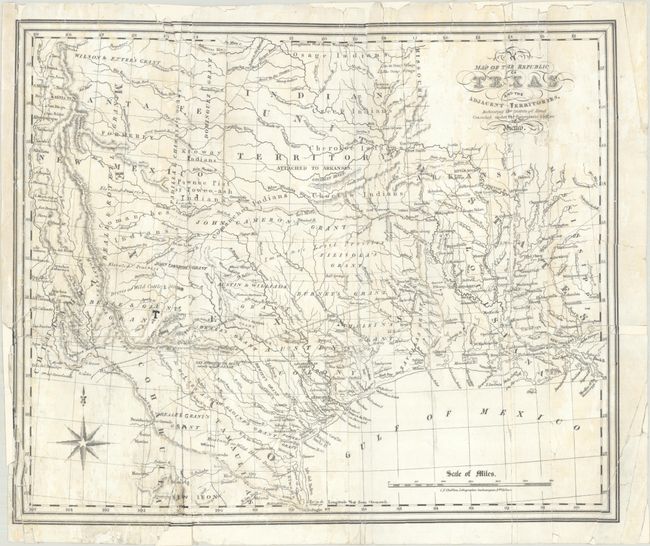
This detailed map of the Republic of Texas was lithographed by Charles F. Cheffins for William Kennedy's influential The Rise, Progress and Prospects of the Republic of Texas, published in 1841. The map represented a radical departure from Cheffins typical work of producing British railroad maps, and therefore seems likely that Kennedy supplied Cheffins with the information to produce the map. Kennedy's work, including this map, was the best description of the history and geography of Texas published to date, and earned him a resolution of thanks from the Texan Congress.
Cartographically, the map shows the Republic in its largest configuration, extending from the Rio Grande north to Santa Fe, Taos, and Spanish Peaks. Most of the Republic is shown divided into land grants including the original Austin's Colony, as well as DeWitt, Burnet, Beale, Fillisola, and Cameron grants among others. The western portion of the Republic is dominated by the powerful Comanche Indians, though the Wilson & Ezter Grant makes an appearance in the far north. Settlement is primarily confined to the south and east of a line from San Antonio to Nacogdoches with place names including San Felipe de Austin, Goliad, Columbia, Montezuma, New Washington, and Liberty to name a few. There is excellent detail of the river systems, topography, wagon roads, trails, forts, mines, and Indian tribes. Notations include a "Mustang or Wild Horse Desert", "Droves of Wild Cattle & Horses", and a Mexican Garrison on the Brazos River.
References: Howes #K-92; Sabin #37440; Streeter (Texas) #1385.
Condition: C+
Issued folding and now flat with numerous tears and separations throughout that have been closed on verso with archival tape. Several small areas of border and some lettering in the map have been replaced in facsimile. Light staining.