Subject: Ohio
Period: 1769 (published)
Publication: Relation Historique de l'Expedition, Contre les Indiens de l'Ohio en MDCCLXIV
Color: Black & White
Size:
12.1 x 9.7 inches
30.7 x 24.6 cm
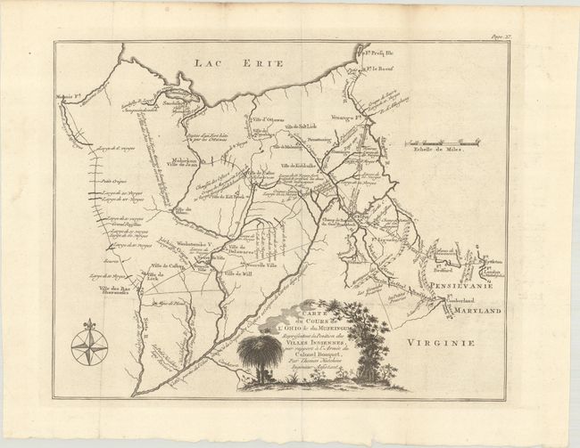
This is a French edition of Thomas Hutchins' map of eastern Ohio and Western Pennsylvania, which was one of the most detailed depictions of the Ohio region at the time, and one of the few based on first-hand observations and surveys. Thomas Hutchins was an American surveyor, mapmaker and the first "geographer of the United States." He was born in the colony of New Jersey in 1730. Prior to the American Revolution, Hutchins served in the British army and participated in the French and Indian War. During the Revolution, he served in the British Army, but in 1779 the British charged him with treason. Hutchins resigned his commission in 1780 and on July 11, 1781, Congress appointed him as "geographer of the United States." After the Revolution, Hutchins continued as a geographer, surveyor and mapmaker in the western frontier. He was given the job of plotting the land set aside for the Northwest Territory by the Land Ordinance of 1785. He laid out four of the Seven Ranges, which organized early settlement of the territory.
Hutchins had previously visited and mapped portions of what is now Ohio on at least 5 separate occasions, including when he participated in Colonel Henry Bouquet's expedition to the Muskingum in 1764. This route, along with 16 encampments made along the way are depicted on the map. A key feature of the map is the location of various Indian villages, as Native Americans were actively attacking the British in order to eject them from the land. Also of note are Forbes Road and Braddock's Road. The rivers in the region are more accurately depicted on this map than previously, with notations on the width of various creeks and rivers.
This map was published in William Smith's Relation Historique de l'Expedition, Contre les Indiens de l'Ohio en MDCCLXIV, which was a French translation of An Historical Account of the Expedition against the Ohio Indians, in the Year 1764, under the Command of Henry Bouquet, Esq., published by William Bradford in 1765.
References: Howes #S-693; Sabin #84647; Smith (Mapping of Ohio) pp. 21 & 59-60.
Condition: A
A crisp impression, issued folding on a bright, watermarked sheet with a couple of tiny holes at fold intersections and light soiling along the edges of the sheet.