Subject: Mississippi
Period: 1824 (published)
Publication: A New General Atlas...
Color: Hand Color
Size:
8.7 x 11.4 inches
22.1 x 29 cm
Finely's maps employ a delicate and elegant engraving style and provided extensive topographical and watershed information. He was the dominant map maker in the United States in the early 1820s into the 1830s. His atlases were very successful, outselling rival atlases by Carey & Lea, and Tanner. His maps were printed on high quality paper and were routinely corrected and updated.
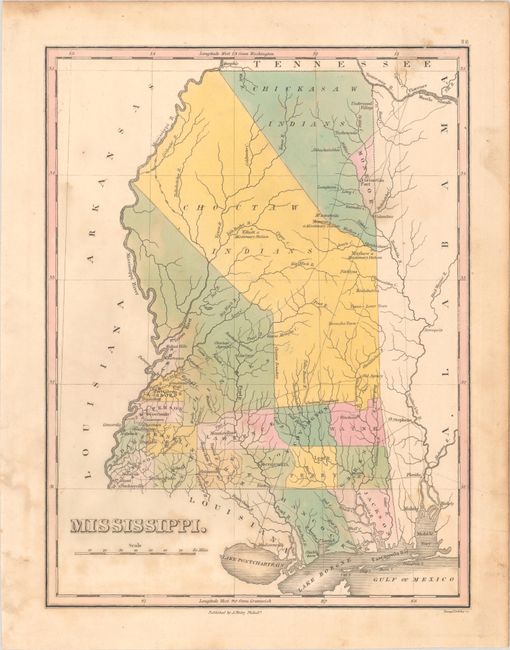
First edition of this handsome map of Mississippi that details the county seats, roads, towns and settlements, and watershed. Development is primarily in the southern portion and mostly along the rivers with virtually no other settlements noted. Monroe is the only county in the north, which was carved out of Chickasaw Indian lands where Cotton Gin Port is located. The early U.S. government built a cotton gin here in 1801 as part of a "plan of civilization" for the Chickasaw Indians. The huge Choctaw Indians region occupies the middle section. In it are noted three missionary stations: Mayhew, Elliott and Monroe, plus the Old Agency, and Yazoom Lower Town. The map shows 18 counties, correct for about 1822, plus the Choctaw and Chickasaw Indian areas. Engraved by Young & Delleker. Finley published his atlases annually between 1824-1834, with one final edition appearing in 1836 (Ristow states his last atlas was 1834).
References: Ristow, pp. 268-70.
Condition: B
Contemporary color with light foxing and some dampstaining mostly at bottom. A pencil drawing on verso does not show through.