Subject: Colonial Mid-Atlantic United States
Period: 1760 (circa)
Publication:
Color: Hand Color
Size:
19.3 x 22.1 inches
49 x 56.1 cm
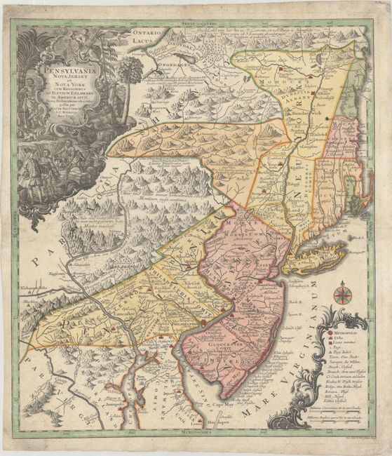
This is a notable pre-Revolutionary War era map based on Lewis Evans’ map of 1749, one of the first and most important maps of the region. This German version had wider circulation than the Evans map and therefore significant influence on the European view of the colonies. It extends from New England to the estuaries of the Delaware and Chesapeake. The British colonies are confined east of the Appalachian Mountains and are depicted with some early, inaccurate, boundary configurations. New Hampshire's entire eastern border is the Atlantic Ocean. Massachusetts is just below New Hampshire, but does not include Boston or Cape Cod, which are shown as part of Connecticut. New York is divided into three sections and includes the western part of Massachusetts and Vermont. The map is graphically engraved to shows mountains, forests, colonial settlements and Indian villages. Two ornate cartouches fill opposite corners of the map. The title is surrounded in an elaborate engraving featuring William Penn bartering with the natives and indigenous flora and fauna. The distance scale and map key are enclosed in a decorative cartouche with a compass rose. Lotter engraved this map for his father-in-law, Matthias Seutter.
References: McCorkle #750.4.
Condition: B+
A sharp impression with full contemporary color, very light soiling, and some small worm tracks along the centerfold that have been professionally repaired, with a minute amount of the image replaced in facsimile.