Subject: United States
Period: 1898 (circa)
Publication:
Color: Printed Color
Size:
12.5 x 8.1 inches
31.8 x 20.6 cm
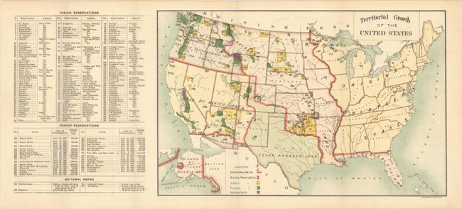
This small map of the United States was issued in the Annual Report of the Secretary of the Interior for 1898 and is significant as the first map to correct previous General Land Office maps and the widespread 19th century misconception that United States’ access to the Pacific Ocean was based on the Louisiana Purchase. According to the annual report (not included): "This error has been corrected on [this] map of the United States for 1898, and the area between the Continental Divide and Pacific Ocean…has been properly indicated as having been acquired by discovery in 1792, exploration in 1805, Astoria settlement in 1811, and Florida treaty in 1819." An extensive index identifies by number and color the location on the map of 175 Indian reservations, Forest Reservations and National Parks. Lithographed by The Friedenwald Company in Baltimore.
References:
Condition: A
Issued folding on a clean sheet with a hint of offsetting.