Subject: Mariana Islands, Taiwan, & Northern Philippines
Period: 1847 (dated)
Publication: Voyage au Pole Sud et dans l'Oceanie...
Color: Black & White
Size:
35.4 x 23.8 inches
89.9 x 60.5 cm
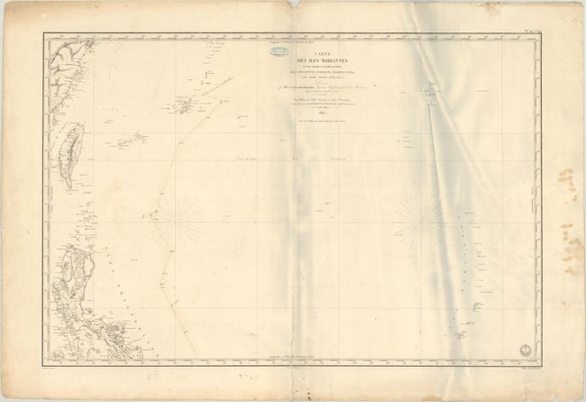
This large French chart by Clement Adrien Vincendon-Dumoulin, Ingenieur Hydrographe de la Marine, centers on the Philippine Sea. It was published in a compendium of charts from various hydrographers. The chart spans from Taiwan and the northern islands of the Philippines in the west to the Mariana Islands and Guam in the east. It includes navigational information, including depth soundings, hazards, and anchorages. There is topographical information on the various islands and place names along the coasts. The information is based on Jules Dumont d'Urville's explorations in the region. D'Urville (1790-1842) was a French explorer who voyaged the south and western Pacific, Australia, New Zealand and Antarctica. He made three important Pacific explorations: aboard the Coquille, commanded by Duperrey (1822-25); commanding the Astrolabe through the Pacific (1826-29); and commanding the Astrolabe and the Zelee in an exploration of the Pacific and Antarctica (1837-40). The emblem of the Depot de la Marine appears at bottom right, and a price of Deux Francs is below the neatline. Engraved by Chassant, with lettering by J.M. Hacq.
References: Phillips (Atlases) #1197-44.
Condition: B
This example includes the stamp of "Francois Roux Hydrographe - Marseille" and sepia manuscript notations charting a course through the sea. There is light soiling, extraneous creasing at right, and a 5" centerfold separation at bottom that has been closed on verso with archival tape. In the blank margins, there are some dampstains and edge tears. There are grayish shadows in the image that are caused by our scanner and do not appear on the map itself.