Subject: Central Africa
Period: 1637 (published)
Publication: Appendix Atlantis
Color: Hand Color
Size:
19.6 x 15.3 inches
49.8 x 38.9 cm
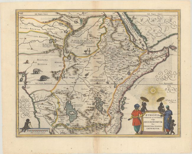
The mythical kingdom of Prester John is one of the most persistent legends of all time and often appears on early maps. This myth had its origins in rumors spread throughout Europe in about 1150 A.D. that there was a powerful Christian priest-king who had conquered the Muslims and founded the kingdom of Kara Khitai in Asia. This mysterious king became a symbol of hope in the Christian world, which at the time was beset by the Mongol hordes. A succession of Dominican and Franciscan missionaries and civil ambassadors were dispatched by popes and European monarchs to search for the kingdom. Many of these emissaries never returned, and those that did reported that the Christian kingdom in deepest Asia could not be found and was probably a myth. But the popular fancy was not easily dispelled, and so over time the location of the kingdom was merely transferred to Africa. Prester John's kingdom can be found on early maps in Scythia, India, Central Asia and Abyssinia.
This map depicts the legendary Christian Kingdom of Prester John. Fabled rivers and numerous exotic animals fill the otherwise empty spaces of the unexplored interior. There is a fair amount of detail on the eastern coast, reflecting the Portuguese and Arab trading interests. Mogadishu, Mombassa, Quiloa [Kilwa] and Mozambique are shown as major towns, and the west coast is shown from Benin to Angola with the Zaire River prominently featured. The Ptolemaic twin lakes of Zaflan and Zembre are shown as sources of the Nile below the Equator, with the Mountains of the Moon (Lunae Montes) shown below. A native family surrounds the title cartouche with chubby infants warding off the bright sun with parasols. This map is nearly identical to Blaeu's map of the same title and is distinguished by the flourishing calligraphy in the oceans. Dutch text on verso.
References: Van der Krogt (Vol. I) #8720:1B.
Condition: B+
A dark impression with an archivally repaired hole and tear in the bottom margin, and light toning and some extraneous creasing along the centerfold.