Subject: Africa
Period: 1568 (published)
Publication: La Cosmographie Universelle...
Color: Hand Color
Size:
13.6 x 10.1 inches
34.5 x 25.7 cm
Sebastian Munster (1489 - 1552) was one of the three most renowned cartographers of the sixteenth century, along with Mercator and Ortelius. Munster's Geographia and Cosmographia Universalis were two of the most widely read and influential books of the period. His editions of Ptolemy's Geographia, published between 1540 and 1552, were illustrated with 48 woodcut maps, the standard 27 Ptolemaic maps supplemented by 21 new maps. These new maps included a separate map of each of the known continents and marked the development of regional cartography in Central Europe. The antique geography was a prelude to Munster's major work, the Cosmographia, which was published in nearly 30 editions in six languages between 1544 and 1578 and then was revised and reissued by Sebastian Petri from 1588 to 1628. The Cosmographia was a geographical as well as historical and ethnographic description of the world. It contained the maps from the Geographia plus additional regional maps and city views with nearly 500 illustrations which made it one of the most popular pictorial encyclopedias of the sixteen century.
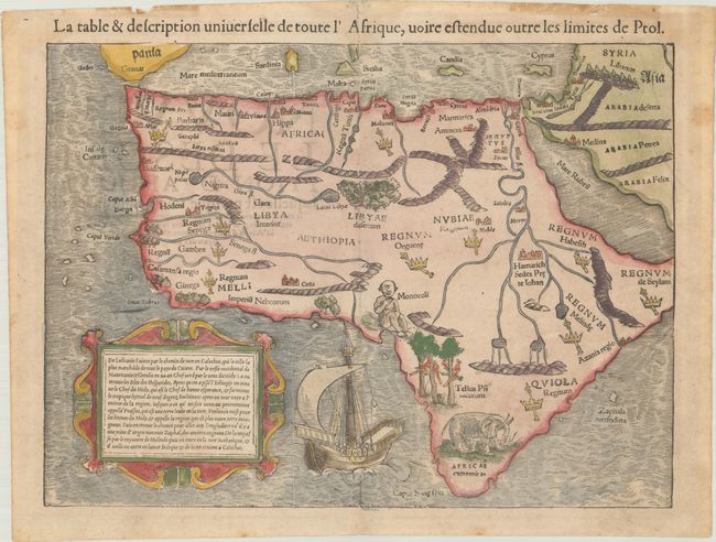
This woodcut map is one of the earliest maps of the African continent that is obtainable by the collector today. It was issued in an early German edition of Cosmographia that also appears in the 1540 Ptolemy edition with Latin text. The Ptolemaic geography, with large rivers and convoluted mountains, is augmented from Portuguese and Arabic sources. From the Portuguese comes Caput Bonespei (Cape of Good Hope) and a small group of islands off the eastern coast named Zaphala Aurifodina that were supposedly the region from which King Solomon imported gold and silver. The Arab kingdoms of Quiola and Melinde appear in eastern Africa and Hamarich, the capital of the mythical Christian king Pester John, is shown at the confluence of the twin sources of the Nile. Crowns and scepters identify the locations of African kingdoms throughout the continent. Noticeably lacking is the island of Madagascar off the southeast coast of Africa. Forests, parrots, an elephant, a Cyclops (Monoculi) and a large galleon under full sail embellish the map. The strapwork cartouche contains a French description of the European discovery of the continent, while the French title is located above the map.
References: Betz #3; Norwich #2.
Condition: B+
Light soiling with extraneous creasing in the top margin and old tape stains along the top edge of the sheet that have caused some tiny chips and tears.