Subject: Southern Wales
Period: 1610 (dated)
Publication: Theatrum Imperii Magnae Britanniae...
Color: Black & White
Size:
20.3 x 15.3 inches
51.6 x 38.9 cm
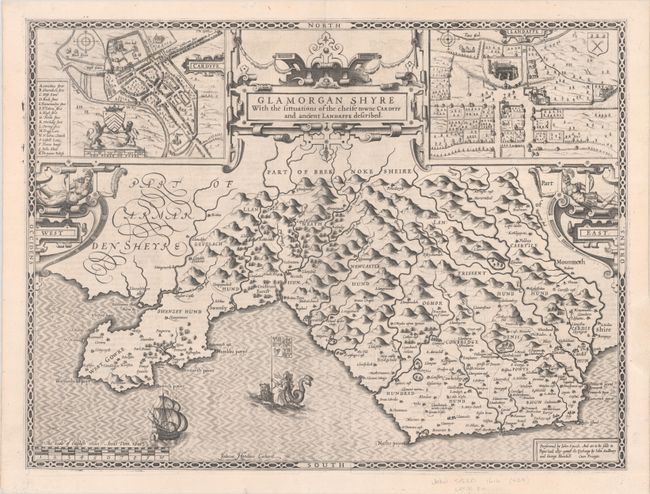
This decorative map of Glamorgan was engraved by Jodocus Hondius and published in John Speed's groundbreaking English atlas. It divides the county into its hundreds and includes up-to-date detail on towns and cities, parks, forests, hills, rivers, and more. An inset at top left shows Cardiff with the coat of arms for the medieval kingdom of Morgannwg and a key identifying 16 sites of interest. Another inset at top right depicts Llandaff with its cathedral and coat of arms. The map is further adorned with a strapwork title cartouche and two strapwork flourishes with figures indicating east and west. In the water there is a sailing ship and an allegorical female figure riding a sea monster and hoisting a flag with the royal arms of Britian. Published by John Sudbury and George Humble in the Latin edition of 1616.
John Speed is best known for this important atlas of Great Britain, which is considered the finest achievement in British map-making. Speed assembled the information for this atlas based on the work of Christopher Saxton and John Norden, updated with new information. He also introduced innovations of his own including the inclusion of town plans, indications of the hundreds, county boundaries, and the coats of arms of local Earls and Dukes. The maps were finely engraved by Jodocus Hondius, one of the preeminent engravers of the period.
References: Shirley (BL Atlases) T.SPE-1d.
Condition: A
A crisp impression with a hint of offsetting and a professional repair to a chip in the right blank margin.